Good Evening:
It was a wild week, and perhaps the weather itself couldn't stand the pressure, and simply folded at the last minute. The general conditions were favorable for a period of snow sometime Friday morning into Friday afternoon, to be followed sleet and rain. It seemed like it would snow for the first time this year. However, our forecast model consistently indicated that precipitation would not arrive until after the cold air had exited the region. Precipitation would arrive, but only at night, and it would be rain. (Some folks did see some snow in Jerusalem at night, and there were light snow showers here in Efrat during the day, so these prior forecasts were very accurate.)
Then, disaster struck. As part of a forecast I made to predict short term weather changes, I looked at what would happen just several hours later. Much to my surprise, the forecast model indicated a snow accumulation. The precipitation -- the forecast showed -- should arrive at the peak of the time of coldest air aloft, which would lead to "convective" snow events.
Unfortunately, it was not to be. I went back after the fact and reran another forecast with an improved representation of melting and cloud processes. This is the forecast model I usually use for longer forecasts. It still showed snow, but no accumulation. Still, it too brought the precipitation earlier than actually occurred (based on an incorrect GFS forecast of the storm position).
It looks like two or three things went wrong Friday morning: i) the best forecast version of the model was not used, ii) the global forecast model (the GFS) incorrectly forecast the position of the storm closer to us than it actually was (it was further west and south), and iii) I was rushed and did not properly review all the data the model was producing.
We already spoke about the forecast model. The incorrectly forecast track of the storm meant that the storm took longer to arrive. This was an issue we spoke about last week, so that the precipitation was "delayed." The fact that I was very rushed (it was Friday morning and there was a client who needed personal service) and the surprise of seeing snow in the forecast meant that I issued my "winter storm warning" without completely reviewing the data. Had I taken more time, I might have noticed that the temperatures were just marginal for snow (and its possible accumulation), meaning at freezing or even above. I might then have tempered my forecast (enthusiasm).
You can imagine that after all this I and the weather are both quite tired. In fact, there is very little weather this coming week. In fact it should be increasingly mild (and sunny -- besides a few possible showers on Monday). The next storm system may not arrive until early next week.
When I was in sixth grade, there was a forecast for rain. It snowed. The next day, there was a forecast for snow -- again. This rarely happened in the 1970s. We'd have snow one week, rain the next, maybe snow the next. So, this was pretty exciting.
After sleeping with difficulty, I woke up in the morning to to see that we'd had just rain, which had almost washed away all of our snow. I was so disappointed that my teacher sent me to the library to learn about the weather. I've been learning since (with a break to receive a liberal arts degree from Oberlin College).
Unfortunately, despite my best efforts, I still make mistakes, and if I don't, then the forecast models do. So, even though I have a high success rate predicting snow, its the last forecast people remember, and I can understand those that are disappointed and those are just happy it didn't snow.
It's a lot of pressure, and I am not sure I want to continue making such difficult forecasts. I don't sleep the night of the storm, and if bit my nails they'd be down to the bone. Maybe it is time for some sixth grader to build the next snowman.
By the way, if you're interested in supporting the site, by helping with advertizing or even by helping to develop crowd sourcing so our forecasts can be even better, then please contact me at weather@weather-it-is.com. You can always contact me wether you have your two-cents to add or not.
Barry Lynn

Sunday, January 28, 2018
Friday, January 26, 2018
Weather It Is (Winter Storm Warning)
Good morning:
There will always be uncertainty, but our latest highest resolution forecast now indicates that snow should arrive to the central mountains today, and accumulate from the afternoon onwards, into the early evening hours.
The forecast shows that snow should arrive just north of Jerusalem in the area of Beit-El for example by noon time, spreading to the hills west of Jerusalem in the early afternoon, arriving in Jerusalem and Gush Etzion. The snow should accumulate 5 to 10 cm in the highest areas of Jerusalem, and 10 to 15 cm in Gush Etzion.
The snow will develop in response to a steady influx of cold air at lower levels, and strong mixing with extremely cold air aloft, as a heavy band of precipitation works its way from coastal cities and inland areas in the north southward to the area of central mountains.
Precipitation should continue into the night, and mix with sleet and rain. The precipitation should taper to light rain after midnight, and showers (or occasional rain/hail) should occur on Shabbat.
Shabbat Shalom,
Barry Lynn
Thursday, January 25, 2018
Weather It Is (Winter Storm Watch)
Good Evening:
The latest forecasts are now in, and there is a digression between the European (ECMWF) and American Forecast Model (GFS). Both the GFS and ECMWF bring winter cold, but the ECMWF actually brings precipitation as far south as Jerusalem in the morning hours. The GFS brings conditions generally favorable for snow, but neither it or the higher resolution WRF brings any precipitation until late in the day.
I plan to make our highest resolution (WRF) forecast update in the early morning hours. By this time, both global forecast models will probably agree how the coming storm will impact our area, and the WRF should tell us what will be -- snow or no snow.
Barry Lynn
Weather It Is (Stormy Weather)
Good Afternoon:
The winter storm watch has been cancelled.
Instead, the latest forecasts from today through tomorrow afternoon show that the heavies precipitation should be located from about Tel-Aviv northward. This is good for the Kinneret.
However, for those hoping for snow in Jerusalem, this seems unlikely as only light precipitation arrives as the coldest air near the surface departs (tomorrow afternoon). Instead, a period of steady rain should occur from late afternoon until the end of Shabbat in the Jerusalem area, with rain also occurring south of Jerusalem in the area of Beer-Sheva (for example).
Our higher resolution forecast is indicating that the arrival of the coldest air aloft (at 500 mb) in the late afternoon will eventually lead to a period of icing associated most likely with thunder and lightning. This would be a coating of ice pellets, rather than snow. High winds tonight along the coastal cities and inland, will likely become gale force winds during the day on Friday from coastal areas, through the center of the country and areas in the desert south.
It's possible that there still could be a light coating of snow during the morning hours of Friday in the higher elevations around Jerusalem, but this is not likely. This can happen before the arrival of the main area of forecast precipitation amounts. It would be better seen on our highest resolution forecast, but we may not make this until tomorrow morning.
Barry Lynn
Wednesday, January 24, 2018
Weather It Is (Winter Storm Watch Continues)
Good Evening:
Meteorologists -- and by extension you -- are faced with a complex weather system that should affect us during the next two to three days. This means that the forecast is actually a debate rather than a statement of what will be.
The storm that should affect us is actually two storms. The first should arrive tomorrow (Thursday) and bring heavy rain, thunder and lightning, and some hail to a large part of the country, with flooding possible from north to south. This storm is suppose to form east of Crete, and move across our area tomorrow afternoon.
The next storm is also suppose to form west of Cyprus, drop southward, and then move across our area late Thursday night into Friday. This means that the coldest air associated with this system will be stuck over the sea before arriving towards morning. This also means that the winds blowing counterclockwise around the storm will have a southerly component, which should force a break in the precipitation even while the coldest air in the lower layer arrives. The lower layer (850 mb), middle layer (700 mb), and 500 mb temperatures will align for snow conditions from about 3 A.M until 2 P.M (1400), but the moisture will align only from about 9 A.M to 2 P.M. Afterwards, the temperatures should be quite cold aloft, and precipitation will become even heavier. It will probably be a combination of rain and ice that continue until Saturday morning. In fact, our higher resolution forecast shows an accumulation of hail late afternoon and evening in Jerusalem and the central mountains.
A secondary system may arrive on Saturday/Shabbat afternoon, bringing more rain and hail.
It all seems relatively simple, except that the passage of the first storm will "shake things up" a bit, and that bit may be enough to affect the position of the second storm. That is, it may move first east of Cyprus, which means that the coldest air associated with the storm will better aligned with the cold. This is indicated by several ensemble members that continue the "cold enough for snow" conditions until evening or even midnight. The probability is less than 50%, but it shouldn't be discounted.
In regard to snow accumulation, this is more likely in the higher mountains around Jerusalem than in Jerusalem itself. The best chance for an accumulating snow both in Jerusalem and its environ is from early morning until afternoon on Friday. The strong winds may make for briefly blizzard conditions.
How much will fall: we still don't know; the debate won't help, but the passage of time will.
Barry Lynn
Tuesday, January 23, 2018
Weather It Is (Winter Storm Watch)
Good Afternoon:
There are those who might look forward to our first snowstorm of the year and those who do not.
This part of the blog is for those who do not. These are the kind of people who think of an accumulating snow as something to be gotten rid of, like unleavened products ("Chametz") before Passover (Pesach).
The weather during the next few days will be quite unusual -- that is atypical. On the other hand, atypical is good because it's unusual. That is, it doesn't happen very often, and when it does its a "here today and gone tomorrow" sort of thing. What am I speaking about? Of course, I am speaking about a storm that will move southward from Turkey, move just west of Cyprus, and then swing around right through our (relatively speaking) little state of Israel. Do you know what the chances of this are? It's simply minute. Yet, sometimes bad things happen (although we hope not too bad) and the unlikely becomes likely. This means that there should be heavy rain on Thursday, strong winds, and hail, and then snow late Thursday night into late Friday. Unlike the previous storm, there just might be enough cold so that snow actually accumulates. However, don't worry, even if the city of Jerusalem comes to a complete stand still on Friday and travel is limited in many mountainous areas, Shabbat should be a bit warmer and Sunday even more. In addition, the latest forecast suggests that precipitation could continue long enough to completely wash away the snow. True, there may be another storm early in the week, but it will probably be rain and be sure to wash away any of the white stuff that survives the rain and not-so-winter sun of Israel. In any case, if you live in the mountainous areas, you can always go to the sea for a soaking rain or to Eilat for sunnier and warmer weather.
This is for those who might actually look forward to snow. This would include myself, and our children, our dog, but not our cats or my wife. My wife does not want it to snow, and if I really could control the weather I would surely stop the storm west of Cyprus, and return it safely to the frozen northern reaches.
In a winter that has fortunately seen many storms, our next arrival will be different. Rather than transversing the relatively warm waters of the Mediterranean (which warms the lower atmosphere and brings us a good soaking rain or just hail in thunderstorms), this storm should arrive from the frozen northern reaches. It should swing just west of Cyprus and then barrel into our area with strong winds, heavy precipitation (hail on Thursday), and most likely a change over to snow Thursday night. Temperatures should be between -1 (or -2 C) at 850 mb, -11 or even -13 C at 700 mb, and -25 to -30 C at 500 mb -- temperatures cold enough for snow. By mid Friday afternoon, the temperatures at 500 mb should become close to -30 C, which should lead to convective events that could bring hail or snow. As the evening arrives, the latest GFS (single deterministic forecast) is suggesting. however, a change over back to hail and rain.
Even with rain, hail, or snow, the cold weather should remain with us into Shabbat morning. True, temperatures should warm early in the week, but Friday and perhaps Shabbat should provide plenty of time to play in the snow, assuming that snow accumulates late Thursday night and Friday. Based on the GEFS, before any changeover to rain there is a 70% chance of a light to moderate coating of snow, and a 40% chance of even heavier amounts, Wednesday's forecast should help us clarify just what kind of snow event we'll be having, and whether there will a light or more heavy accumulation.
In the meantimes, we look forward to welcoming visitors from warmer and rainier areas to our soon to be snowy landscape.
There is even a chance of another storm, but most likely rain, early next week.
Barry Lynn
Saturday, January 20, 2018
Weather It Is (A Break And Then Stormy)
Good Evening:
Winds gusted to 120 km/h in Tel-Aviv on Thursday night/Friday and heavy rain fell in many locations. There was also plenty of thunder and lightning to light the sky. The strong thunderstorms produced lots of hail (some of which I gathered in my hand Friday morning).

Despite the frequent rain, though, the accumulated amounts so far are still below normal for the season (see:
http://www.ims.gov.il/IMSEng/Tazpiot/RainObservations/).
The strong thunderstorms occurred because of relatively cold levels in the upper atmosphere, with relatively warm and moist temperatures lower down. A radiosonde measurement taken at the IMS office in Bet-Degan near midnight Friday measured 1 C at 850 m, -10 C at 700 mb, and -27 C at 500 mb. When we discussed the upcoming situation last week, we mentioned that for snow to occur the temperatures at 850 mb would be below zero (ideally -1 Cor lower), and -12 or lower at 700 mb. Combined with -27 C at 500 mb (which was colder than suggested by the forecast at the time), it would have been an ideal snow situation. It was not meant to be.
I am sure that there are plenty of folks who wondered why I mentioned the possibility of snow at all. For instance, at best there was a 40% chance that temperatures would be cold enough for snow. I might have easily just said that it was more likely that there would not be snow. However, it is my job to spice up the weather forecasts, to grab the readers attention, and to build at least a bit of excitement.
There may be those who are disappointed that it didn't snow, and there might be those who are disappointed in me. Yet, what readers forget is that I am also disappointed the weather "didn't work out." I have feelings too -- I'm not just a reporter: I'm involved.
Anyway, the weather will warm up a bit on Sunday, but then a front will pass through Sunday night and we'll be headed to what could be a week of very wet and chilly weather. There will probably be two storms that arrive, the first on Tuesday and the next on Thursday or Friday. The first should bring rain, while the forecast indicates that there is a 25% chance of snow with the second.
Our snow changes may in fact be higher than in our last go around because this storm will be arriving from the north. This means that the low-level winds circulating around this storm will spend less time over the ocean, and have less time to warm enough to produce rain instead of snow. The "fly in the ointment" is that the cold air to our north is not as cold as typical for this time of year, so we may just get plain rain.
You may remember that it wasn't so long ago that we were quite worried that this winter would be another drought year. On the other hand, you may not have been worried about this, and this is what concerns me.
In fact, a lot of strange things have been happening to me lately. For instance, this morning I opened the door to our house and the power went off. The power came back, so I went out and opened the door again -- the power went off. I went to a neighbour, opened his door and the power came back on.
Of course, it was a coincidence, and one shouldn't make anything more of it.
But, this is not what I am speaking about. For weeks, I had been arriving at the Bet-Knesset on Friday evening on-time only to wait about 5 minutes for services to begin. A few weeks later, I arrived to the same Bet-Knesset five minutes late and the congregation was already half way through the Shabbat services. It was like I had come to a different Bet-Knesset.
A few days later, I lay down for a snooze, expecting to wake up about 12:30. I woke up a few times, and here are the times I saw on my watch: 12:23, 12:27, 12:18, 12:27, and 12:23. Weird.
Prior to the start of our rainy period it was very warm. My wife said to me: "I love these weather changes, as I can wear sandals at the end of December." I looked at her and wondered if this person was really my wife.
Last week was the Torah Portion "Va'era," except this happened two weeks in a row.
I think these strange occurrences can be explained by Quantum Mechanics or how the world works on the scale of very small particles, and what this implies for us. For instance, if one uses an electron gun to shoot electrons one at a time at a double slitted barrier, the electrons appear to pass through both slits at the same time, as implied by a wave interference pattern that is found at the detector on the other side (see, for example:https://plus.maths.org/content/physics-minute-double-slit-experiment-0 ). However, if we try to observed these single electrons passing through the slits, the interference pattern is eliminated and the pattern detected is what we expect (one electron passing through one of the slits one at a time).
The results is a conundrum. It appears that the essence of a our world is a probability distribution, where the electron can be at both slits at the same time or some fraction of of the time, but when we try to observe what is happening, the electron behaves like we expect in our world. This leads to strange situations. For instance, if we were to place a cat in a chamber with a radioactive trigger, quantum theory implies that it should be both dead and alive at the same time (since the decay of a radioactive particle from a single atom sometimes occurs and sometimes it doesn't, but until we check it is in both states). This is the conclusion of a thought experiment proposed by Erwin Schrodinger http://whatis.techtarget.com/definition/Schrodingers-cat ). The cat should remain thus until we (an observer) check to see what happened to the cat, and this is referred to "as quantum indeterminacy or the observer's paradox."
To most people, this seems like an impossibility. The cat is either dead or alive but not both. One not so obvious solution to this problem is to simply accept the fact that in one "world" the cat is dead, while in the other the cast is alive, and that the observer (that's us) exist in two different realities. Or, to put it succinctly: there are two of us!
Taking this a step further, it means that when a card that is balanced on its edge and falls in one direction, it also falls some percentage of the time (depending on its tilt) in the other direction, in another universe, and so-on. We the observer, however, do not know that these other universes exist or that (perhaps) they are being created all the time.
Except that I know -- because I have been moving between universes (even though this is suppose to be impossible) for the last month or so. The proof: I was living in a universe where it didn't rain and now it seems to rain all the time. There's also my wife... or at least someones wife. And, there's probably a universe where it did snow, and snowed a lot, and I can't wait to get there.
Barry Lynn
Thursday, January 18, 2018
Weather It Is (Winter Weather Warning)
Good Afternoon:
The latest forecasts are in, and they indicate that snow should fall in the northern mountains of the Golan, but not in the central mountains.
The temperatures at 500 mb (and 700 mb), though, are cold enough to bring potential thunderstorms and hail, which could make for slippery driving conditions. However, surface temperatures should be above freezing, so the ice should melt off given enough time.
Winds should also be gale force, so caution should be taken.
The rain should arrive this evening and then should taper to showers later on Friday.
A longer lasting and very high precipitation producing storm should arrive next week, most likely beginning on Tuesday. The rain may actually continue into early next week.
Barry Lynn
Wednesday, January 17, 2018
Weather It Is (Stormy Weather Again)
Good Afternoon:
The latest forecasts from the GEFS (Global Ensemble) indicate that the upcoming storm will most most likely not produce any accumulating snow in the Jerusalem area.
The basic "problem" is that the area of coldest air is forecast to slide just to the north and east of Israel Thursday night, meaning that precipitation will be lighter than thought originally, and the chance for snow particles to grow large is quite low.
However, winds will gust to gale force levels, and rain amounts will still be on the heavy side, so at least there should be more rain to add to our already (what was) normal totals. Rainfall amounts should be heaviest up north.
Looking ahead: next week looks to be stormy, and we'll keep in mind that cold air may be arriving from the north. In such a situation, the longwave pattern is more greatly amplified (called an "Omega" pattern after the Greek letter Omega). This means that the lower level air is more likely to remain cold and that the stormy weather could possibly remain pretty much all week long.
Barry Lynn
Tuesday, January 16, 2018
Weather It Is (Winter Storm Watch Continues)
Good Evening: After issuing my "Winter Storm Watch" for Thursday night and Friday morning, the forecasts from the GEFS trended a bit warmer. There were still some forecasts with unusually cold temperatures, but the majority were pointing towards "just" a rain event. This was discouraging if you're a snow-liking person.
I know where my wife stands on this matter, because she was going around telling people that I said that it wouldn't snow. What I really said was that looking at the weather maps Tuesday morning made me less optimistic, but not completely pessimistic. Well, "A man hears what he wants to hear and disregards the rest..." (so aptly said Simon in Garfunkel in the song "The Boxer.")
However, today's (0z (00:00 UTC)) forecasts were again pointing towards a cold event. Looking at the GEFS mean weather forecast field maps, one notes the arrival of unusually cold air Thursday night into Friday morning. In terms of the potential for snow accumulation, this will be helped out by very cold temperatures at 700 mb in the presence of strong vertical velocities. The ideal temperature for "growing snowflakes" (interlocking dendrites; see:http://www.iweathernet.com/educational/winter-precipitation/general-snow-forecasting) is between -12 and -18 C, and at the moment 40% of the forecasts indicate a drier, more likely to accumulate snow after the rain transitions to snow Thursday night.
In the last blog, we spoke about the possibility of snow at even low (or lower elevations). However, the current forecast puts this probability at just 10%. Still, the ECMWF forecast at 500 mb is colder than the GEFS, so this may not be the last word on this subject.
In the meantime, Wednesday (tomorrow) should bring more rain, and Thursday's storm should bring even heavier precipitation, strong winds, and a chill just about everywhere.
The temperatures should warm up on Shabbat and Monday, but the next storm should also bring chilly weather (with another chance for snow) mid-next week.
In terms of actual snow amounts, the reader should check back on Thursday morning for an estimate by location.
Barry Lynn
Monday, January 15, 2018
Weather It Is (Winter Storm Watch)
Good Evening:
There is a winter storm watch for Thursday night into Friday morning for the higher elevations of Jerusalem, Gush Etzion, and the northern mountains.
The latest (0000 UTC) GEFS forecast mean temperatures at 850 mb are just below freezing, with temperatures at 700 mb (the level near which snow grows most quickly) comparatively even colder with more than 60% of the forecasts below -12 C. The "fly in the ointment" are the forecast temperatures at 500 mb. Similar to a storm last year that brought a light accumulation to Gush Etzion, most forecasts within the ensemble are not below -25 C. However, 20% of the forecasts are, and apparently the ECMWF forecast at 500 mb is colder (in the mean) than the GEFS. If these colder forecasts verify, there could be snow in Mitzpe Ramon as well as areas lower down (e.g., Ramat Bet Shemesh) -- but this is unlikely.
Snow accumulation amounts -- like always -- are very sensitive to elevation heights and the degree of cold aloft, and it isn't possible to speak about accumulation amounts just yet. In addition, this storm should be arriving from the west, meaning that relatively warm sea-temperatures could cause the snow to melt as it approaches ground level. Moreover, temperatures on Shabbat and Sunday are forecast to be well above freezing, which should melt just about any snow. So, the snow may literally be here Friday morning, and gone by Shabbat morning or afternoon.
Nevertheless, the upcoming storm is forecast to be quite strong with gale force winds, high waves, and probably thunder and lightning. Flooding is again likely within cities and the desert areas to the south.
Until then, rain is again forecast for Wednesday and possibly next week as temperatures become chilly again as the next storm arrives.
Barry Lynn
Sunday, January 14, 2018
Weather It Is (Winter Comes)
Good Evening:
You've probably heard: the weather indicators are pointing towards rainy and unusually cold weather. Yet, our overall weather pattern hasn't changed much. We're still expecting a series of storms to move across the eastern Mediterranean this week (the first was last night and tonight (Monday-night), the third should be on Wednesday, a fourth on Friday, and another possibly early next week.
What's different, and importantly so, is that extremely cold air should settle in west of Greenland, over the northern European countries of Great Britain, Norway, Sweden, and Finland, and northern Russia. This is a long wave pattern that has been generally present for the last couple of weeks, but now is forecast to amplify as it gets colder. This is a change from last week's forecast for this upcoming time period.
Really, the most important center of cold air as far as we're concerned is the one forecast to be located over northern Europe, where our Friday's storm is suppose to originate. This is unusual because as noted at the Jerusalem Weather Forecast Facebook site (https://www.facebook.com/notes/jerusalem-weather-forecasts/a-detailed-summary-of-what-brings-major-snow-to-jerusalem/1957311591189265/) almost all of our snowstorms originate with cold air that plunges southward from Siberia through Turkey into the far eastern Mediterranean. One such storm was the December 2013 storm that buried Jerusalem in heavy, heavy snow over a three day period.
In this week's end of the week storm (Thursday night into Friday), the cold air should build southeastward from northern Europe. Some of the Global Ensemble Forecast System (GEFS) forecasts suggest that snow levels could be very low, as the mean temperature between the surface and 500 mb may be below freezing. The GEFS puts the changes of this type of cold at about 30%. The global model from the European Centre for Medium Range Weather Forecast (ECMWF) is actually forecasting snow in Jerusalem, even though this model's resolution is greater 10 km (so the topographical heights in the model are quite a bit lower than actual).
New forecasts are arriving as I write this, and I've been told that they are a bit warmer than today's earlier forecast. Right now, we can see with high certainty through Thursday, but Friday's storm remains at least as far as possible snow is concerned a mystery.
Stay tuned!
Barry Lynn
Wednesday, January 10, 2018
Weather It Is (Rainy Weather)
Good Evening:
It does feel like winter here, but not a particularly cold winter. In fact, temperatures have not yet been below freezing (here in the mountains of Gush Etzion). In fact, based on the data provided at http://cci-reanalyzer.org/wx/DailySummary/#t2anom one notes the temperatures worldwide are 0.7 C above average, while the northern hemisphere is 1.2 C above average. The only locations with below normal temperatures today (Wednesday) are Canada, eastern Russia, and points north over the artic ocean. So, we shouldn't expect any real winter weather in the Middle East anytime soon.
Yet, not all is bad -- winter wise. Our weather pattern has become fairly active and another storm should be moving across the eastern Mediterranean by the end of the week. In fact, a cool front will arrive Wednesday night and there will be a slight chance of showers on Friday, as well as a higher chance of rain Motzei Shabbat (Saturday night) into Monday morning. Winds will also be strong out of the west from Sunday into Monday, and there should be snow on the Hermon. Temperatures will also cool some more.
Moreover, there is a 50% chance that another storm will provide another dosing of rain from Thursday of next week onwards, so winter -- even though a mild winter -- continues.
In contrast, it also seems that the terror attacks never stop. The death of Raziel Shevach hits home: even though I didn't know him -- we all feel like family here.
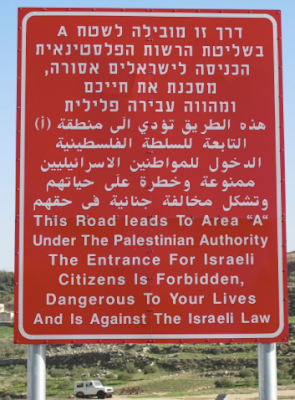
Of course, if the terror attacks did stop, then there would be no need for signs like these at the entrance to Palestinian towns. In fact, there is one just down the road from the northern entrance to Efrat.

It does feel like winter here, but not a particularly cold winter. In fact, temperatures have not yet been below freezing (here in the mountains of Gush Etzion). In fact, based on the data provided at http://cci-reanalyzer.org/wx/DailySummary/#t2anom one notes the temperatures worldwide are 0.7 C above average, while the northern hemisphere is 1.2 C above average. The only locations with below normal temperatures today (Wednesday) are Canada, eastern Russia, and points north over the artic ocean. So, we shouldn't expect any real winter weather in the Middle East anytime soon.
Yet, not all is bad -- winter wise. Our weather pattern has become fairly active and another storm should be moving across the eastern Mediterranean by the end of the week. In fact, a cool front will arrive Wednesday night and there will be a slight chance of showers on Friday, as well as a higher chance of rain Motzei Shabbat (Saturday night) into Monday morning. Winds will also be strong out of the west from Sunday into Monday, and there should be snow on the Hermon. Temperatures will also cool some more.
Moreover, there is a 50% chance that another storm will provide another dosing of rain from Thursday of next week onwards, so winter -- even though a mild winter -- continues.
In contrast, it also seems that the terror attacks never stop. The death of Raziel Shevach hits home: even though I didn't know him -- we all feel like family here.
Of course, if the terror attacks did stop, then there would be no need for signs like these at the entrance to Palestinian towns. In fact, there is one just down the road from the northern entrance to Efrat.

Sometimes I wonder what it must be like to live on the other side of such a sign. Wouldn't you feel embarrassed to live behind such a sign? I've also wondered what might be written on the other side of the sign itself. Perhaps it is written: "Entering Paradise -- Israeli territory."
However, here is what is more likely written on the other side:

The sign shows two examples of the amount of money paid to Palestinian terrorists who commit crimes, including murder. The worse the crime, the more they get paid. If they're married, etc, they get paid more.
There are efforts within the US Congress to pass a law deducting from aid given to the Palestinian Authority the amount paid to terrorist families and terrorists themselves ($350 million in 2017). There are also proposed laws in Israel to deduct monies collected in taxes. However, these bills are moving slowly because there is a fear that reducing monies to the Palestinians will cause greater "unrest." So, after an attack they arrest those directly responsible, and then restore the "situation" to what it was as quickly as possible. In my mind, this is like trying to fend off a voracious animal, where the slabs of meat are really human sacrifices.
Israel use to have a very generous policy for families, too. The purpose of our family policy was different, though, to encourage parents to have more children. The more children parents brought into the world, the more money they would get, and the amounts went up "exponentially." This proved to be too expensive, so payments now are much less than they use to be.
Let's make it a lot more expensive for the Palestinian Authority (which claims to be an actual state) to murder Israelis. There won't be any less Palestinian children being born, but fewer will be murderers, and fewer will grow up to be so.
Barry Lynn
Sunday, January 7, 2018
Weather It Is (Nice For Now)
Good Evening:
After the storm, the temperatures should moderate until Wednesday evening. Winds will switch from a northerly to southerly direction, and the relatively humidity should drop. However, a cold front should arrive Wednesday night, and it will usher in cooler and moister air. This initial push of cool air should bring a chance of showers Wednesday night.
At the moment, a more substantial rain should arrive for Shabbat. This will be the result of a storm moving along the southern coast of the Mediterranean and then by Cyprus. However, this storm may pass to far north, which would lead to generally lower rain amounts that the past storm.
Last week's storm was a severe storm, complete with heavy rain, gale force winds, hail, lightning and thunder, as well as high waves. Trees fell down, roads were flooded, and there were quite a number of lightning strikes, some that knocked out power (there were actually about 2500 strikes, about 300 more lightning strikes in this storm than average for the month of January).
Some of you may have noticed that there was dust before the arrival of the rain. The presence of dust often increases the intensity of rain in a humid environment. The reason is that high dust concentration leads to the formation of small drops, which ascend above the freezing level. These drops can then freeze (releasing heat as they do so). The increase in heat leads to stronger updrafts, and the mixing of water and ice, which produces hail as well as thunder and lightning.
There was also the news of the storm along the east coast. It underwent what is termed "explosive cyclogenesis," where the central pressure fell 24 mb in 24 hour or less. The central pressure in our storm fell about 8 mb in 16 hours, or about 1/2 mb per hour. So, even though the effects of our storm were severe, the intensity change was only about half the storm that effected the east coast (especially the mid-Altantic states). The reason for this is that our storm developed near Cyprus, and then moved eastward over land. When it moved over land, it lost its supply of moisture. In contrast, the east coast storm stayed over water as it developed, allowing for continued flow of moisture into its circulation, and continued development.
Stay tuned for more news on our upcoming storm.
Barry Lynn
Wednesday, January 3, 2018
Weather It Is (Winter Weather Warning)
Good Evening:
The strongest storm of the winter season is upon us. It should bring heavy rain and gale force winds, as well as thunder, lightning and hail. Rain should develop along the northwest coast towards morning, and then spread inland (including Jerusalem) by late afternoon Thursday. The coldest temperatures aloft should arrive tomorrow afternoon, and this will be the time for the greatest potential for thunderstorms.
The global ensemble forecast (GEFS) shows that there should be two waves of low pressure, the first arriving tomorrow afternoon and the second Friday morning. There will be strong vorticity advection with both events, indicating high upward vertical velocities. The strong winds off the sea and strong upward motion should bring > 50 mm of rain in many locations, with 100 mm possible. Rain on Friday should spread to the south, and the rain will generally taper off to showers on Shabbat.
The second wave of low pressure should also bring the gale force winds.
For those who like snow, you'll have to go to Hermon. Most of the world's cold air is over the United States, where it is incredibly cold. In fact, it even snowed in Florida and southern Georgia, and a developing storm could bring a foot of snow (or possible more) Thursday along coastal cities such as New York City.
Our storm will be strong and wet, but it won't be, as noted, particularly cold. We still don't see very cold weather in the forecast, although it should remain chilly until early next week. Milder weather should proceed our next possible storm that may arrive very late next week.
While the weather is unusual - in its extremes -- I also had an unusual conversation with the service center at Cell-com. About two years ago, I cancelled one of our cellular lines. I remember answering then that I was sure I wanted to cancel the line. Since then, we've requested bills be sent by surface mail, e-mail, and even carrier pigeon. Had we received a bill, we might have noticed that we were still being billed for the cancelled line.
During the call with the service center, I pointed out that we hadn't used the line since then, and that the extra line was for one of our kids. It wasn't something we were keeping for posterity. The pleasantly sounding service representative mentioned that there was no record of this conversation (as it happened in person), and that there were many customers who kept old numbers (paying a monthly fee, regardless of use). After some prodding, she checked with her manager who said that it was company policy not to refund money for unused lines.
I pointed out that it wasn't only unused, it was cancelled. I said that we were probably going to cancel our service and move our two active lines elsewhere. She checked again with her manager and said it was company policy not to offer refunds.
I asked her why it isn't company policy to keep its customers. I gave Cell-Com 24 hours to decide. Apparently, "they" don't care.
Unfortunately, charges are often added to bills and it is up to the customer to refuse them after the fact. There should be regulations against this, but our Knesset members have been corrupted by big money. I have a feeling that if things don't change, there will be new protests, but they won't be over cottage cheese.
Barry Lynn
Subscribe to:
Posts (Atom)