Good Afternoon:
The weather is certainly beautiful. It is the kind of day that makes you want to be outside.
However, the ridge of high pressure responsible for our clear skies will move away as a cool front passes through tonight and tomorrow. The cool temperatures associated with it will give way to a significant warm up as a strong ridge builds into the eastern Mediterranean on Sunday.
Yet, the ridge will be swept away by a strong cold front on Wednesday. At the moment, only the GFS is indicating heavy rain by the end of next week, while its ensemble of members indicate lighter rain and weaker upper level cold air than the GFS.
The main difference between the models if grid resolution, with the GFS having about 4 times the grid resolution than its ensemble.
In any case, we can see a return to a winter chill, but not much else.
Shabbat Shalom,
Barry Lynn

Friday, February 26, 2016
Tuesday, February 23, 2016
Weather It Is (A Storm Winds Down)
Good Afternoon:
After receiving a number of complaints, I must say that "if" I offended any sticklers to the calendar, I must apologise.
It turns out that I really raised some hackles when I said that it had snowed only three (or so times) in March since the 1880s.
Well, I have a list on my desk that counts 15 times just since 1920, and this is leaving out the time it snowed in Gush Etzion (15/03/07) one morning several centimetres.
For all we know, there could be further days missing from the official list. On the other hand, 15/100 times 100% means that about 15% of the time it does snow in March.
We're nearing the end of February, and temperatures will be warming up as a weak ridge of high pressure develops on the heels of our last heavy rain storm.
The warm weather should last into Erev Shabbat when a weak frontal system will bring back a touch of winter. There is a 25% chance that the touch will bring a nip in the air and some showers on Shabbat into Sunday.
Looking further into the beginning of March: we see a few days of mild weather before the middle of next week ends with a winter chill. Regarding possible rain amounts with the return of winter-like temperatures, the forecasts are not clear about this yet, as the forecast strength of the 500 mb trough remains comparatively weak within the set of global ensemble members.
Barry Lynn
Monday, February 22, 2016
Weather It Is (Storm Update)
Good Morning:
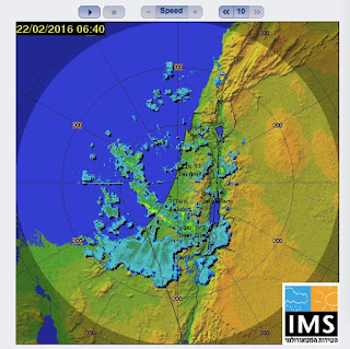
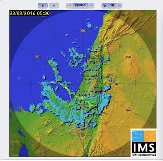
Below there are two examples of precipitation streamers affecting the area of Beer-Sheva.
The 4 km ensemble shows that the highest probability of streamers is from late night (that just passed) until early afternoon.
There is some discrepancy between the 18 GMT and 12 GMT updates from last night. The former shows the heaviest rain (50 to 100 mm) from Jerusalem south to Hebron, while the former shows that the heaviest rain ( > 100 mm) in the area of Beer-Sheva. The latest updates shows 25 to 50 mm by Tuesday morning in this area (but heavier amounts on the mountains east of route 90). In the area of the Kinneret, expect 10 to 25 mm total storm amounts.
All forecasts continue to show rain today from Netanya southward into the southern Arava. Another band of rain should affect the northern areas (especially along the coast) late this afternoon. The heaviest rain should be focused on southern areas tonight.
Regarding the potential for "catastrophic" flooding. As noted, we don't run a hydrological stream model, so we can only note the possibility based on historical analogy.
The next couple of weeks show some ups and downs in temperatures, with a possibility of storms late week or early next week and then sometime late next week.
Barry Lynn
Sunday, February 21, 2016
Weather It Is (Update)
Good Afternoon:
The latest 1.3 km/4 km high resolution run (and accompanying ensemble) still indicates the potential for catastrophic flooding in the area between Beer-Sheva and Mitzpe Ramon.
Greater than 100 mm of rain should fall generally in this area.
Heavy rain on the mountains east of route 90 should also flood this road as well.
There will be 50 to 100 mm on the mountain tops that drain into the Dead Sea Basin, as well as twenty to fifty mm will fall on the Dead Sea-Basin itself, meaning that river and stream flows should also be quite strong in this area as well.
Here is a link to a similar event of the past, although here the center of the heavy rain will be further north than occurred then.
Barry Lynn
http://ims.gov.il/NR/
Weather It Is (Heavy Rain/Flooding)
Good Morning:
A winter storm is approaching, and it will bring heavy rain and strong winds, as well as cool temperatures (with some snow on the Hermon).
The latest 18 GMT WRF high resolution forecast shows rain developing in the coastal cities this morning, and spreading the east to the central mountains (as well as the Jordanian and Dead Sea Valleys) this afternoon.
The high resolution forecast, which now extends out until Tuesday evening, shows 10 to 25 mm of rain in the north (with localized higher amounts), 50 to 100 mm in the center including the Metropolis of Tel-Aviv and the city of Ashkelon, as well as Jerusalem southward to Hebron.
From the area of Hebron to Beer-Sheva, the forecast shows greater than 100 mm. From Beer-Sheva southward, the forecast shows 25 to 50 mm to the lip of Mitzpe Ramon. Rain is also forecast southward into the Arava on the mountains to its east.
Forecast rain amounts per three hours should be between 10 and 25 mm, which will lead to flooding of streams and rivers, especially late tonight into Monday evening.
The rain should taper to showers late Monday in the north and Monday night in the center, but rain should persist in the south until late Tuesday.
This is a potentially dangerous situation for those travelling on roads prone to flooding. Moreover, it highly recommended not to park your car anywhere near areas susceptible to flooding, even infrequently.
Barry Lynn
Saturday, February 20, 2016
Weather It Is (Severe Flooding Possible)
Good Evening:
Another winter rain storm is upon us -- with some snow possible on the Hermon.
A very warm layer in the middle atmosphere (at 700 mb -- reminiscent of the summertime inversion) will be replaced by winter cold and plenty of moisture. In addition, temperatures will be dropping off at both 500 mb and 850 mb to help support cooling and convective thunderstorms.
Showers will develop tomorrow and heavy rain as well by evening. We're expecting 10 to 25 mm in the north and 25 to 50 mm of rain generally from the central-north to the south by Monday afternoon. This will lead to flooding in the Jordanian and Dead Sea Valleys.
In addition, a moist streamer of air is forecast to impact the area south of Askelon southeastward to between Beer-Sheva and Mitzpe Ramon. Forecast rain amounts should be between 50 to 100 mb, which will cause severe flooding. Heavy rains extending to the mountains east of route 90 and southward into the Arava will also cause flooding in these areas.
Strong winds are expected Sunday afternoon and evening, with the possibility of gale-force winds with higher gusts.
The forecasting of these "streamers" of moisture is not a straightforward matter, although our last forecast of heavy rain from a streamer during the last real cold spell was right on the money.
Showers may persist until Tuesday, but the week should end on a warm note.
Beyond the end of the week, there is a 60% chance temperatures will continue their upward climb.
No major storms are definitely seen at this time, but the chance persists for winter to return.
Barry Lynn
P.S. For those who still hope for a late season snowfall: I was told that three of the last four March snow storms occurred before the 1900s, with only one March storm since then in 1980.
Thursday, February 18, 2016
Weather It Is (For What The Bell Tolls)
Good Afternoon:
The bell is tolling on our nice bout of warm and sunny weather.
In fact, the global ensemble forecast is suggesting that the next rainy system may be more than a puddle maker.
There's been a shift in the forecast, which indicates that the next weather event will be more prolonged and more intense than previously indicated.
Instead of low pressure weakly developing over our area on Monday and quickly moving east (in the old country we use to say: "out to sea."), there is the potential for more significant rain Monday into Tuesday with snow on the Hermon.
Temperatures will stay on the mild side until tonight, but then the first of two fronts will arrive.
The front should bring a layer of Sinai dust on Friday and showers on Shabbat, as well as much cooler temperatures.
There will be a quick warm up Saturday afternoon and Sunday ahead of Monday's storm, but then temperatures will fall precipitously and stay on the cool side until late next week.
The storm is still a few days away, and there is still a lot of uncertainty about the strength of the upper level low that will be responsible for maintaining and intensifying the precipitation amounts (in the presence of plenty of low level moisture).
However, there is the potential for flooding in river beds and streams in the Jordan and Dead Sea Valleys, as well as strong winds on Monday into Tuesday.
The dust will vacate with the rain on Friday evening north to south.
Shabbat Shalom,
Barry Lynn
Tuesday, February 16, 2016
Weather It Is (Nice Weather, Then Uncertainty
Good Afternoon:
The weather is really nice. It's warm, the skies are a pretty blue, and the winds are light.
A few intrepid folks have actually switched out their wardrobes to spring.
One must ask, though, is this wise?
A ridge of high pressure will remain fully in control of our weather until Friday when it should give way to an approaching cool front. Hence, Shabbat will be noticeably cooler and there will be a chance of showers. Temperatures will rebound a bit on Sunday but then a stronger front and storm should arrive for Monday and Tuesday.
Looking beyond mid-next week shows no clear signal.
In fact, you may remember that a short time ago we trumpeted the latest CFS forecast that indicated that March would be cooler, wetter, and stormier than normal. I did this without my usual warning about model uncertainty.
Why? Because the time series of CFS forecasts should take into account model uncertainty (they probably do).
Yet, what is apparent from these links:
http://www.tropicaltidbits.com/analysis/models/cfs-mon/2016020900/cfs-mon_01_apcpna_month_me_1.png
http://www.tropicaltidbits.com/analysis/models/cfs-mon/2016021500/cfs-mon_01_apcpna_month_me_1.png
http://www.tropicaltidbits.com/analysis/models/cfs-mon/2016020900/cfs-mon_01_T2ma_me_1.png
http://www.tropicaltidbits.com/analysis/models/cfs-mon/2016021300/cfs-mon_01_T2ma_me_1.png
http://www.tropicaltidbits.com/analysis/models/cfs-mon/2016020900/cfs-mon_01_z500a_me_1.png
http://www.tropicaltidbits.com/analysis/models/cfs-mon/2016021500/cfs-mon_01_z500a_me_1.png
for example, just six days apart that the Climate Forecast Systems Model cannot predict the possible slow-mode changes in ocean temperatures, currents, snow melt, etc, that can affect next months weather. So, the issue here is model physical integrity on top of model uncertainty -- a very bad combination for weather (or seasonal) prediction models.
So, even if we could possible look beyond next week's uncertainty (attributable to initial GFS model uncertainty), we certainly cannot say anything meaningful about next month's weather (at least not those who rely on dynamical forecast models).
There are those who claim success at seasonal forecasting using statistical relationships Well, they didn't do so well this year even in the presence of a very strong El-Nino. My strong feeling is that dynamical forecasts taking into initial condition uncertainty is the way to go (towards more accurate seasonal forecasts), but we'd also like to go to Mars and then the stars, and we're not there yet.
So, is there any economic value in these longer range forecasts? The question should really be asked and answered.
Barry Lynn
Thursday, February 11, 2016
Weather It Is (The End Of Winter -- Objection!)
Good morning:
Yesterday's strong upper level trough combined with a Red-Sea Trough to produce a period of moderate rain in the central mountains and some southern areas yesterday, as well as showers last night in many locations.
In the last blog, I pointed out that a strong ridge of high pressure would be building into the eastern Mediterranean. I wondered if the lack of apparent cold air suggested that we might slide into March without a return of winter weather. After all, in the year 2010, the end of January was basically the end of winter, and it didn't really rain again until after the tragic Carmel wildfire in December. The same storm that fanned the flames of the fire also blew the tiles off our roof.
No sooner was the ink dry on my blog when a very informed reader wrote to vociferiously object. He sent me to some rather useful links that provide a summary of CFS (Climate Forecast Systems) model data.
Here's one: http://www.tropicaltidbits.com/analysis/models/cfs-mon/2016020900/cfs-mon_01_z500a_me_1.png
another: http://www.tropicaltidbits.
and one more: http://www.tropicaltidbits.
suggesting that March will be more stormy, wetter, and cooler than normal.
As we gaze forward to the last week in February we do indeed see that our steadily warming temperatures will return to more winter-like values from about February 19th onwards.
Until then, after a chilly get go today the weather will simply be nice (sunny, warm, and dry).
Of course, everyone wants to know if it will snow again this year. The long range ensemble indicates about a 20% chance of a strong storm at the end of the month.
But for now, it's only February 11th and we've got quite a way to go before then.
Barry Lynn
Yesterday's strong upper level trough combined with a Red-Sea Trough to produce a period of moderate rain in the central mountains and some southern areas yesterday, as well as showers last night in many locations.
In the last blog, I pointed out that a strong ridge of high pressure would be building into the eastern Mediterranean. I wondered if the lack of apparent cold air suggested that we might slide into March without a return of winter weather. After all, in the year 2010, the end of January was basically the end of winter, and it didn't really rain again until after the tragic Carmel wildfire in December. The same storm that fanned the flames of the fire also blew the tiles off our roof.
No sooner was the ink dry on my blog when a very informed reader wrote to vociferiously object. He sent me to some rather useful links that provide a summary of CFS (Climate Forecast Systems) model data.
Here's one: http://www.tropicaltidbits.com/analysis/models/cfs-mon/2016020900/cfs-mon_01_z500a_me_1.png
another: http://www.tropicaltidbits.
suggesting that March will be more stormy, wetter, and cooler than normal.
As we gaze forward to the last week in February we do indeed see that our steadily warming temperatures will return to more winter-like values from about February 19th onwards.
Until then, after a chilly get go today the weather will simply be nice (sunny, warm, and dry).
Of course, everyone wants to know if it will snow again this year. The long range ensemble indicates about a 20% chance of a strong storm at the end of the month.
But for now, it's only February 11th and we've got quite a way to go before then.
Barry Lynn
Wednesday, February 10, 2016
Weather It Is (Red-Sea Trough Update)
Good Afternoon:
Maximum rain amounts are now forecast to be between 5 and 10 mm, with could lead to small stream flooding in the area of the Dead Sea Valley.
Otherwise, scattered showers will be occurring generally into the night.
Barry Lynn
Maximum rain amounts are now forecast to be between 5 and 10 mm, with could lead to small stream flooding in the area of the Dead Sea Valley.
Otherwise, scattered showers will be occurring generally into the night.
Barry Lynn
Tuesday, February 9, 2016
Weather It Is (A Red Sea Trough/Spring)
Good Evening:
A Red Sea trough will combine with an upper level trough to produce potentially heavy, localised rain on Wednesday.
At the moment, rain is more likely south of Tel-Aviv eastward to the Jerusalem-Hebron corridor, and south to Mitzpe Ramon.
Rain showers are expected to develop Wednesday morning in the west and and last into the evening in the eastern part of the country.
We'll try to provide more exact information about rain probabilities tomorrow morning.
Otherwise, the long range forecast is suggesting that winter may be taking a bow -- and that the final curtain will follow shortly thereafter.
Of course, the end of February is not necessarily the end of winter, but the next two weeks will definitely feel more like spring than winter.
The warm weather will be courtesy of a ridge of warm area over the eastern Mediterranean sea. It is the eastern part of a very amplified trough/ridge couplet. In fact, unseasonably cold air will plunge far south into western Europe in response to a very strong area of low pressure moving in off the eastern Atlantic.
For us, though, the weather will just be nice.
Barry Lynn
Sunday, February 7, 2016
Weather It Is (Our Winter of Discontent)
Good Morning:
There's something to be said for an old-fashioned rain storm. Temperatures at higher atmospheric levels in the central and northern mountains are cold enough for some wet-snow to mix in with the rain, but surface temperatures are still above freezing, so rain is the story.
I never thought that I would enjoy rain, but I do now.
As my son said last night: "why doesn't the radar look like that when it snows?" Most of the time it does, but last time it didn't.
A second upper level surge of cold air will help maintain rain across much of the country until the evening, and then rain showers (with the exception of the Hermon) will gradually end tonight (or tomorrow morning).
However, a very strong upper level vorticity max (at 500 mb) will approach on Wednesday. Right now, it has only limited lower level moisture support -- so we may be back to rain or wet-snow showers, although a heavier downpour can't be ruled out.
At the moment, it's unclear just how well the system will organise itself into a lower level trough, so we have to leave this open for now.
Looking further ahead. It will stay will a winter chill until the end of the week.
While it should slowly warm up, thereafter, we do see some potential for another storm to follow.
Yet, no snow is in the forecast in the next two weeks (unless we get lucky this Wednesday), and so we may leave this winter as a winter of -- perhaps -- our discontent (for more than one reason).
Barry Lynn
Thursday, February 4, 2016
Weather It Is (Rain on the Way/Snow on the Hermon)
Good Evening:
Our relatively mild and sunny past few days will transition to something more akin to winter.
In fact, we're going to have a classic winter storm with the heaviest rain falling in the north, as well as a heavy snow on the Hermon (we have a new "Hermon" forecast page).
By Sunday evening, 25 to 50 mm should fall in the north -- including the Kinneret Basin, with 50 to 100 mm of rain in the area of the far north and Golan/Hermon. Additional rain should fall Sunday night into Monday.
Graupel (ice pellets) are possible in the area of the central, northern mountains, but temperatures should stay above freezing (outside the Hermon) throughout this rainy event.
The next storm is actually the first of possible several storms to impact our area in the next two to three weeks. They are forming in response to ridging into central Europe and the confluence of and fairly active northern and southern Jet streams.
Moreover, the Arctic Oscillation will be turning positive soon, and combined with a positive North Atlantic Oscillation will set up for a possible mid to late February snowstorm.
Flooding will be possible in the Jordan and Dead Sea Valleys, from Saturday morning and late Saturday afternoon, respectively.
Strong to Gale-Force winds should occur from Saturday afternoon until Sunday morning.
Shabbat Shalom,
Barry Lynn
Monday, February 1, 2016
Weather It Is (A Tale Of Two Storms)
Good Evening:
Two storms are on their way. However, we're going to warm up a bit until the first one arrives. Ironically, the colder (and stronger) the upcoming "event" the warmer it will probably get before it gets here.
Temperatures will reach their peak about Thursday afternoon, and then fall to chilly levels by Shabbat when there is a 70% chance of moderate rain. There will actually be a chance of showers tomorrow Tuesday, but these will be of the tropical (and light) variety.
Some of the ensemble members are showing cold enough temperatures to produce some rain mixed with wet snow at the higher elevations. The probability is about 15%, but the chance for snow on the Hermon is much higher.
The weather will moderate a bit early next week through mid-next-week. However, another, more potent storm could threaten at the end of next week. Some of the ensemble members show temperatures cold enough to produce snow in the area of Jerusalem, but many don't -- so stay tuned.
Barry Lynn
Subscribe to:
Posts (Atom)