Good Evening:
There is much "action" on the horizon. Most encouraging is the waviness of the upper level (500 mb) pattern, where two waves will pass by on Monday and Tuesday night. The second will be colder than the first, and it might lead to some snow showers Tuesday night.
Looking at the lower atmospheric levels, there is some humidity, but temperatures should stay above freezing, so any snow showers should just melt.
The cold temperatures should moderate on Wednesday into the end of the week, but we see indications that early next week might turn quite cold, bringing back a chance of snow. This storm (the third in our series) shows possible phasing between the lower and upper levels, which would bring lots of precipitation, wind, and snow.
We seem to be seeing a lot "opportunities" (~30% chances) for snow this year on the forecast maps. If the global model has predictability beyond five days, then one of these weeks it will snow.
It was noted by a fellow blogger at "Jerusalem Snow" that the Climate Forecast Systems Model shows a cold January in store for us. This is a change from what it showed in its three month outlook prior.
Barry Lynn

Saturday, December 31, 2016
Friday, December 30, 2016
Weather It Is (Cold, But Not Much Else)
Good Afternoon:
Some light rain is expected from late tonight into late afternoon/evening Shabbat.
The rain will arrive with a strong chill, and there could be some wet snowflakes mixed in with the rain.
The cold should continue into Wednesday, with another chance of rain Monday Night/Tuesday.
Otherwise, the cold and the rain should take a break until the end of the week after next.
Shabbat Shalom/Chanukah Samaech,
Barry Lynn
Thursday, December 29, 2016
Weather It Is (Storm Update)
Good Morning:
For the last few days, the forecasts from the global ensemble have minimized the possibility of a snowstorm for us this Shabbat and early next week.
True, they continue to show a period of precipitation from Shabbat into Tuesday. However, none of the forecasts show enough cold at the lower levels to provide the background conditions for a good snow. Instead, the real cold is suppose to move north to south over Greece. Moreover, as the storm system moves east it is suppose to weaken, providing us with only a glancing blow.
About 30% of the ensemble members hold back the arrival of the upper level support for this storm system until about Tuesday morning. These actually forecast a colder outcome at upper levels. If they verify, there could be a period of wet snow about Tuesday morning.
Nevertheless, the weather pattern is more wintry than not, and the period of Shabbat through Tuesday will be chilly with temperatures struggling to rise through the single digits (much above zero) throughout the period. In fact, it won't warm up until the middle of next week.
On another note: I watched Secretary Kerry's speech last night. It was an impassioned speech, and heartfelt. He correctly noted that the Israeli building of towns in areas that might become land as part of a future Palestinian state is not consistent with the "idea" of an independent Palestinian state. He also made some good points about the potential benefits of a thriving Palestinian democracy for Palestinians themselves. He also noted the need for Israel to provide more land for the growth of Palestinian towns.
However, he skirted the most obvious reasons why a peace agreement has failed to materialize: the very people who we are suppose to negotiate with are the very same who support terrorism (e.g, in the media, religious institutions, and schools), and find the idea of a Jewish state anathema. So, when he talks about making known the United States disapproval of such activities, he is speaking to the very same people who find all of these activities perfectly acceptable, encourage them, and whose ultimate goal is not the continued existence of Israel, but its demise.
In other words, there is no one to speak to on the other side, and there is a fundamental and existential difference between building homes (they can be removed) and a world view that precludes the existence or acceptance of the State of Israel (in any form).
No less important: the idea that the international community together with the Palestinians will guarantee or insure our security against threats is laughable (just look across any of our borders).
Moreover, the idea that peace between us and the Palestinians will lead mitigate the threat from Iran, Hizbollah, Syria, ISIS, and Hamas is false.
Finally, it is Israeli overall control of the area that enables Palestinians to access modern roads, health care, and even the modern economy. One might also note that the Palestinian State (that exists in some form even now) is in no way a democracy, and would -- if left on its own -- become an Iranian protectorate.
Barry Lynn
Monday, December 26, 2016
Weather It Is (Winter Continues)
Good Evening:
We're expecting a strong rain system to move in tonight and tomorrow (Tuesday). It should bring between 25 to 50 mm of rain across the coastal areas and into the central mountains. More than 50 mm of rain is expected in the area of Haifa and northward. The storm should bring strong winds.
After light showers on Wednesday, another storm should arrive on Thursday with another round of rain. Through it all, temperatures should remain on the chilly side.
Friday night should see the arrival of another storm, with temperatures aloft becoming cold enough for snow. However, a long fetch over the sea may warm lower atmospheric temperatures enough to limit snow accumulations. The highest accumulations should be in the highest elevations around Jerusalem and the north.
As for amounts: anything we can write now is just guessing. We need to wait until our high resolution forecasts come into play within three days of this possible snow event.
Otherwise, the maximum winds will be either strong or gale force, but not hurricane force winds as indicated by some of the ensemble forecasts the other day.
The cold weather with the next system should last into early next week.
Barry Lynn
Saturday, December 24, 2016
Weather It Is (Heavy Rain/Snow?)
Good Evening:
Not too long ago, it was legal to burn the Jewish people in gas ovens. Now, it is illegal for Jews to live in Eretz Israel...
A series of winter storms will impact our region from tonight through the week. Each will come with strong upper level support, which means that we should expect heavy rain and thunderstorms (with hail, graupel). More than 100 mm of rain are predicted in the Tel-Aviv area within the next day and a half. Winds will be strong late tonight, possibly gale force on Tuesday morning, and there is a chance for storm-force (more than gale), and even hurricane force winds at end of the week.
There is a 10% chance of wet snow with the rain on Tuesday morning.
As for the end of the week, Friday will see the onset of the most severe storm of the winter, with very heavy rain expected. At the moment, it looks like the storm will be approaching from the west, which means that the sea-surface temperatures will likely warm the cold in the lower atmosphere. This means wet-snow, rain, or rain mixed with snow, where any snow accumulation amounts will depend highly on elevation.
At the moment, it is too soon to predict if snow will accumulate, but the storm has the potential to be the most severe this year, as well in several years (December 2010).
Barry Lynn
Friday, December 23, 2016
Weather It Is (Yes or No)
Good Afternoon:
Today a streak of rain should fall from southwest to northeast across southern Israel. The rain is associated with middle and upper level moisture. The rain amounts at any hour should not be significant, but the total amounts may lead to some stream runoff. Like the rain the other day, it may leave a bit of dust on the windshield.
Otherwise, late Saturday should see the arrival of a more significant storm forming over Cyprus (the "Cyprus Low"). Rain with this storm should be heaviest in the center and central mountains, and possibly last into Monday, with another round on Tuesday.
These weather events, although significant in their own right, pale in the shadow of the next. All eyes remain glued to the end of the month calendar period where a significantly cold and wet feature remains present in the deterministic models and ensemble means. Such is the potential strength of the end of the year storm that we can clearly see its imprint on the upper level winds (as represented by the absolute vorticity) within a sharp and mean looking upper level trough.
We're about a week away, and we can be hopeful that the end of this week will shed more light on what will happen at the end of next.
Shabbat Shalom,
Barry Lynn
Wednesday, December 21, 2016
Weather It Is (Winter)
Good Afternoon:
After taking a back seat to fall (some might even thought spring temperatures) winter has arrived.
There is a chill in the air and there are frequent periods of rain.
Looking at today's weather map, we see strong winds tonight as an upper level disturbance passes by to our northwest. This should bring a period of rain along the NW coast.
By Shabbat, temperatures will fall again, and a heavier rain should arrive (again with strong winds). The storm system that will bring the next bout of winter weather can be clearly seen on the GEFS mean maps (on our site) in both cold upper air temperatures and strong vorticity advection. Temperatures in the upper atmosphere will below - 25 C, but temperatures in the middle and lower atmosphere will be relatively warm (for snow, meaning rain). The storm is actually passing over the sea after heading down south from past western Turkey, so this will ameliorate the low level cold normally associated with type of system. Still, this type of scenario is good for producing thunderstorms and graupel. The inclement weather should last into Sunday.
Then all eyes will turn (perhaps all eyes have already turned) to the monster of a system being noted on multiple forecast models and in the GEFS. The GEFS shows about a 30% chance of real winter cold and snow at the end of the month, but the fact that the European model and the deterministic GFS continue to show this feature (and coupled with a strong NAO) gives us a bit more hope than our typical maybe it will snow comment.
Of course, anyone who has seen the new movie "Rogue 1" can't help from having a bit of hope.
Sincerely,
Barry Lynn
Monday, December 19, 2016
Weather It Is (Heavy Rain Arrives)
Good Evening:
The "burst" of rain has arrived. Still expecting temperatures to fall to zero 0 tonight in the higher elevations with rain possibly mixing with snow, or becoming wet snow (with no accumulation -- likely).
We heard thunder a few minutes ago. The thunderstorms associated with the approach of the cold air appear on the map below, with EN's "Pulse-Rad" (radar) overlaid.
Weather It Is (Unsettled and Cold)
Good Afternoon:
The latest forecasts show a burst of precipitation arriving in the late afternoon/evening to central coastal areas, and the mountains of Jerusalem and Gush Etzion. Temperatures at 850 mb should be below 0 during tonight, so rain could end as a period of wet snow or rain/snow mixture. Due to uncertainty in the forecast temperatures, it would be a mistake to speak about any snow accumulation with any confidence -- other than to say it is unlikely.
Looking further ahead: the global ensemble forecast continues to oscillate between various forecast outcomes. The previous forecast had a near 100% chance of rain for Shabbat, early next week. Now, however, rain may arrive as early as Thursday.
The chance of snow on Thursday is just 10%, while it is a bit higher for the end of the week.
I think I will mention to NCEP that the global ensemble (GEFS) seems to be having a hard time producing consistent forecasts this year.
Barry Lynn
Sunday, December 18, 2016
Weather It Is (Stormy Weather, Snow?)
Good Morning:
Highlights
1) A period of rain and wind moving north to south today.
2) Late afternoon/evening rain along the center coast and rain/snow in the central mountains (Monday evening)
3) A larger and potentially more significant storm at the end of the week.
The forecasts from the GEFS (global ensemble) have been what one might term unreliable, perhaps beset by poor model initialization. On its behalf, the type of weather that leads to our more winter-like/snowy weather originates in areas of the globe (the polar regions) that have fewer observations, so the model has to make "educated" guesses about the weather conditions there.
In any case, our high resolution forecast for today shows a cold front moving north to south today, bringing with it a period of rain as it passes (dissipating south of Gush Etzion).
What we see is that tomorrow's weather will bring another shot of even colder air. The GEFS still shows temperatures just below freezing sat 850 mb, with some temperatures at 500 mb as low as -29 C. Our high resolution model shows precipitation from this system, but temperature forecasts from it depend on which member of the ensemble we use, so it doesn't really tell us if it will snow. The mean ensemble forecast is close to -25 C, but some temperatures are forecast to be as high as -22 C. For it to snow in the central mountains, the actual temperatures need to be on the cold side of the forecast range. Let's say that there are equal probabilities of moderate rain, rain/snow, and snow tomorrow evening.
After a break of a couple of days, the forecasts show a much stronger system arriving, with precipitation from Thursday into Shabbat (and gale force winds). This system shows many of the forecasts clustering on temperatures that will bring a rain/snow mix with some cold enough for snow.
Keeping in mind that it snows one or two times a year here (at best -- except in 1991/92 when it snowed multiple times even at elevations as low as 300 mb), perhaps the odds favor that this storm will be at best just some wet snow mixed with rain.
Shavua Tov,
Barry Lynn
Friday, December 16, 2016
Weather It Is (Change In The Forecast)
Good Afternoon:
There have been some strong, localized storms in the coastal areas, and rain from central Israel (Tel-Aviv) and northward will persist into Shabbat.
Otherwise, model forecast have swung back a bit towards winter, after being strongly committed to winter at the beginning of the coming week, only to recently build a ridge of higher pressure in the eastern Mediterranean instead. Now, however, the European model and subsequently the GFS (and its ensembles) are indicating that winter (with heavy rain) will return on Sunday, and then Monday brings a good chance of rain, and even a 15% chance of snow.
What is a 15% chance of snow? Why is he telling us this? Strictly speaking, about 3 of the 20 (15%) of the ensemble members show the possibility of the middle and upper atmosphere supporting snow in the higher elevations on Monday. However, all the forecasts show temperatures near or below freezing in the lower atmosphere. Moreover, the strength of the building trough in the eastern Mediterranean is still uncertain, as there is still some divergence in the forecasts, and the trend is towards colder weather.
It depends in part on how the low over Spain develops, and where it moves, and more recent forecasts show it relatively weaker and further west, which means it should interfere less with the building of the trough in our area.
If all this sounds a bit like hand waving, it is -- because the global forecasts lack the information and resolution to forecast specifics more than 3 or 4 days in advance. They are usually good (but not so good recently) at forecasting trends and general outlooks, but we need more information than this to forecast snow here because out temperatures during snowfall events are so close to freezing.
That's why we don't run our high resolution models more than a few days. However, keep in mind that within about three days, our high resolution forecasts usually have good enough information from the global models and the grid resolution to be pretty accurate, which is reflected in the comments we receive from viewers of the site (thank you).
Moreover, with our lightning network in place, we can now run rapid updates of our forecasts that provide high short-term accuracy to predicting severe storms.
Shabbat Shalom,
Barry Lynn
Tuesday, December 13, 2016
Weather It Is (Extreme Winds, Heavy Rain, Extreme Cold)
Good Evening:
Warnings: Heavy Rain, Gale Force Winds, Chill
Our high resolution forecasts and ensembles show heavy rain should sweep down from the northwest tonight, producing > 25 mm in 3 h in locations along the central coast, and between 50 to 100 mm of rain by Friday over large areas of the country (with the exception of the far south),
The GEFS (global ensemble) shows a strong storm spinning up over Cyprus tonight and moving eastward inland by Friday. The strong low pressure area is associated with very strong upper level support (vorticity advection). Moreover, the ensemble shows high humidity levels even up to 500 mb, especially tonight when the heaviest rain is expected.
The rain will be accompanied by chilly temperatures. In fact, temperatures are just cold enough for snow at lower levels, but upper levels (500 mb) do not support snow formation. However, with the chill, there may be some ice.
The winds should peak tomorrow afternoon at Gale force or even strong Gale.
The chill will moderate briefly, but the global ensemble is indicating that temperatures will fall below freezing in the higher elevations on Sunday and stay there into Tuesday morning.
The ensemble shows extremely cold temperatures at 700 mb, and some forecast members indicates similarly intense temperatures at 500 mb.
At the moment, though, the humidity profile shows saturated conditions in the lower levels, but less
than saturated conditions at 700 mb. This means that a large precipitation (snow) event is currently not likely.
The mean ensemble maps (on our web site: https:\\weather-it-is-israel.com) show a broad area of cold approaching from the northeast, as well as a diffuse vorticity field. This may simply reflect the uncertainty in the forecast, but also that this will be mainly an extremely cold event with snow showers.
Stay tuned.
Barry Lynn
Monday, December 12, 2016
Weather It Is (One Storm And Then A Jerusalem Snow Storm?)
Good Afternoon:
We're waiting for forecast updates.
However, our upcoming severe wind and heavy rain storm may be followed by extreme cold and heavy snow (in the mountainous areas, and even down to a few hundred meters of elevation) early next week.
Barry Lynn
 For example:
the following shows the forecast GEFS ensemble 850 mb temperatures for the next
two weeks. The ensemble of
temperatures indicates that there is a high probability that it will be very
cold, and even
For example:
the following shows the forecast GEFS ensemble 850 mb temperatures for the next
two weeks. The ensemble of
temperatures indicates that there is a high probability that it will be very
cold, and even extremely cold. If you combine this information with
other information from the same forecast, you can infer that we may have a significant snow storm in about a week's time.


We're waiting for forecast updates.
However, our upcoming severe wind and heavy rain storm may be followed by extreme cold and heavy snow (in the mountainous areas, and even down to a few hundred meters of elevation) early next week.
Barry Lynn
December 12th, 2016
Today’s note is based on some e-mail correspondence that I
received. One of the
correspondents prefers to remain anonymous, while the other (Jonathan Hoffman)
contributed much of the material on the AO and NAO that follows below.
Basically, we often look for atmospheric “connections” between
large-scale patterns we can measure, and the weather that eventually impacts
our region – in this case with a potential large snowstorm.
For example:
the following shows the forecast GEFS ensemble 850 mb temperatures for the next
two weeks. The ensemble of
temperatures indicates that there is a high probability that it will be very
cold, and even
Jame
Gleick is credited with the following:
“Big whorls have
little whorls
Which feed on their velocity,
And little whorls have lesser whorls
And so on to viscosity.”
Which feed on their velocity,
And little whorls have lesser whorls
And so on to viscosity.”
In between the large atmospheric
whirls, there are smaller wave patterns, which contain within them the stormy
weather systems that impact our weather, and may bring our first significant
snow in two years.
In this vein, I received an e-mail from an anonymous writer who
wrote:
“A huge uncertainty in the teleconnections forecasts,
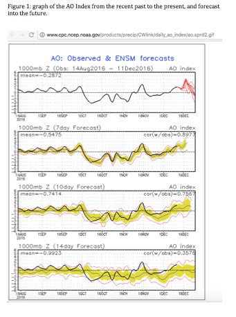
especially after the 16th has been gradually resolved, it seems, in
favor of a strongly rising AO (Figure 1). The
NAO forecast is less certain, as forecast divergence still exists after 16th.
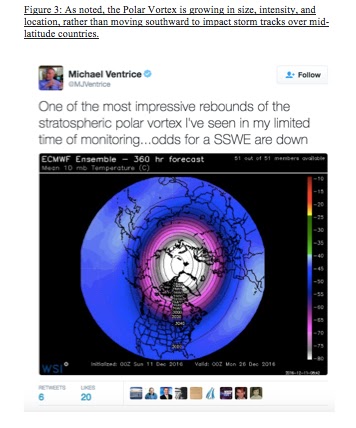
“The stratospheric PV (Fig. 3; Polar Vortex) is forecast to make a strong recovery.
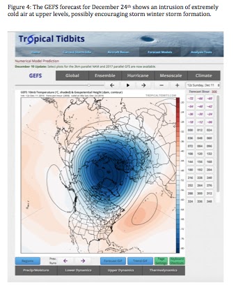
A lobe of it may pass close by, around the 24th, according to GEFS (Figure 4).
“What does this portend for the weather in our area? And, of course,
everyone wants to know – ‘how does that affect our snow chances?’"
As noted by Mr. Hoffman: “Statistically
speaking, Israel is more likely to receive cold air troughs with the polar jet
when the NAO and/or AO are positive.” Such polar outbreaks increase our chances for snow. He correctly, I think, attributes this to
what might be called an “open highway” in the streams of air that move across
our globe. “The polar jet is more
easily able to flow north across the [Eastern United States and Atlantic Ocean]
because it is not ramming into circular domes of air in the North Atlantic and
Arctic regions.” One important factor, in other words, is that storms that start on
the northeast USA coast should have a clear path across the Atlantic ocean until they often come
to “rest” in the area of Greenland, which then encourages a ridge (a bend to
the north in the river of air) to form over the UK and western Europe, with a
corresponding trough (bend to the south) of cold Russian air extending southwestward
into the eastern Mediterranean. This, he notes “is more likely to happen with a
+NAO and/or +AO.”
In contrast, if the AO and NAO were negative, storms would be less
likely to move into Greenland. The
Jet Stream (streamers of high winds in the upper atmosphere) and storm within
it would forced to stay south of that region
thanks to the “dome”of cold air that has moved southward off the poles in association with the measured negative NAO and/or -AO. Instead, storms would
likely pass over the Atlantic Ocean, under the dome, and enter western Europe
in a way that would start the European ridge further east such that it might
even go over Israel. This would then send abnormally warm air into our region,
killing the chances for snow.
Or,
the trough would form over central Europe, directing typically wet, but not
particularly cold air masses into our region.
Mr.
Hoffman provides a couple of examples from recent forecasts for this week
(starting December 11th, 2016). He notes the position of the polar
and southern jet streams in Fig. 5 and the temperature anomalies associated
with them. One notes how the polar jet bends northward over Europe, creating a
ridge, and then comes downward with a trough close to Israel. This causes
relative warming over Europe and relative cooling over Israel (and nearby
countries). Note, also the southern Jet stream depicted here, which can funnel
storms moving eastward across the Mediterranean into the trough, spinning up a
potent storm in the base of the polar trough (just to our northwest).
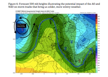
Figure
6 shows more clearly the influence of a low pressure system and the NAO for
creating this overall pattern. He points out that the low-pressure storm system
is placed in the north Atlantic, a bit west of the UK, close to Greenland, and
that a ridge forms over western Europe before dipping down as a trough over the
eastern Mediterranean.
A similar
storm situation, but stronger and better defined, may bring us our first
significant snow in two years.
Sunday, December 11, 2016
Weather It Is (Gale Force Winds)
Good Afternoon:
Weather forecast accuracy has improved greatly since I started weather forecasting years ago, and the last few years have seen improvements still.
However, it is apparent that a lack of good information (weather data) in areas that really influence our weather (like the far northern latitudes, and perhaps the oceans) has set some sort of limit on our ability to peer over the horizon (from one week to the next).
For instance, last week we saw chances of snow for these coming days rise and fall, and finally fall again. As new information enters the system, it should probably rise (and keep rising), or reach a peak and then fall and keep falling at some point in the advanced forecast. This seems to occur about 5 or 6 days out. We would like a few more days to be able to confidently look into next week.
This week's coming storm should produce heavy rain and gale force winds from Tuesday into Wednesday. It may even get cold enough at the surface to freeze a few locations, but chances are small (other than on the Hermon where snow should fall again).
Yesterday's forecast showed that next week would most likely warm up a bit. There was even a larger chance that it would warm up a lot compared to more colder, winter-like temperatures.
Today's forecast is quite different, with about a 40% chance of our first snow of the season coming early next week.
However, there is a fine line here between just plain cold with some wet snow and really cold with an accumulating snow. And, of course, for those who don't like winter weather -- there is a 40% chance it will be just wet, and even a 20% chance it won't rain at all (the warm and dry scenario).
I plan to provide an update later today or tomorrow. Hopefully, there will be enough information in the model to indicate which scenario is more likely.
Barry Lynn
Friday, December 9, 2016
Weather It Is (Wet)
Good Afternoon:
Next week's storm has been in the news.
However, the latest Global Ensemble Forecast System run suggests that rain is likely on Tuesday into Thursday (with strong winds), but that the real cold air will stay to our north.
There is a 15% chance that temperatures will fall off to freezing or below after the storm passes, but the next chance for something really cold (and snowy) isn't until the week after next, and chances are not very high.
So, we're in for a period of typical winter weather: cold and rainy from time to time.
Shabbat Shalom,
Barry Lynn
Wednesday, December 7, 2016
Weather It Is (When I Was A Kid)
Good Morning:
When I was a kid I used to like to talk about the weather. So, one might wonder why I haven't been speaking about the weather for the last week. I really wanted to say something, but as Joe Friday of "Dragnet" might have said: "give us the facts, Ma'am," which is not the same as "just the facts, Ma'am." The first implies uncertainty, while the second implies certainty (and we're not).
Also, my mother used to complain when I provided more than just a cursory appraisal of the next storm, as she too wanted just the facts. After all, I had given her some rather useful hats and other sundries to keep her warm, and I am sure that she wouldn't have wanted to arrive at school with the wrong ones, and then have to explain that her child really didn't have the facts, or at least the right ones.
So, that is where we are: I want to say it, and I want to write it, but the forecast models we have are not capable enough to predict the next two weeks. If they were, then the possibility of our next snow storm would not come and go even on the 10 day forecast. I mean, if there was a 20% chance of a mid-December snow storm a few days ago, and then no chance, and now its back, this indicates that the global forecast models just don't have enough information (or physics capability) to forecast this far in advance.
So, the facts are the GEFS 12 UTC forecast model is indicating that mid-December just might bring a very early snowfall to even the Jerusalem area.
The probabilities are about 25%, which theoretically means that three-quarters of the time we write this blog it won't snow then. On the other hand, since the forecast models are somewhat data sparse in the areas where the real cold originates from, the possibility of snow may really be higher.
We will see in the next few days whether we should get excited enough to hope for the details to show themselves in our higher resolution forecasts. If they do, I plan to produce some longer higher range higher resolution forecasts than currently on the site, to give an advanced look at just what may be.
Send your thoughts and/or comments or numerical weather forecast tidbits as you see fit.
Barry Lynn
Wednesday, November 30, 2016
Weather It Is (Severe Winter Storm)
Good Evening:
The rain has been a little slow in arriving, but the atmosphere will turn favorable for a soaking rain from the north to the central areas starting tomorrow and lasting into Saturday. Moreover, the storm will bring gale force winds from late morning Thursday into late Friday.
As the storm arrives, there is a 60% chance of > 10 mm in 3 hour of rain in the Tel-Aviv area.
With the winds and rain will come cold temperatures as the storm moves in from the northwest. Our 4 km WRF 36 to 72 hour forecast shows snow on the Hermon as well. The same maps are indicating the potential for flooding rains from Haifa Northward, and in the area of Askhelon eastward to the Dead Sea Valley.
The cold will last into Sunday, and then temperatures will moderate for a few days.
The long range forecast shows a 10% chance of snow on or about the anniversary of the giant snow of December 2013.
Barry Lynn
Sunday, November 27, 2016
Weather It Is (Severe Winter Storm)
Good Evening:
A severe winter storm will arrive Wednesday and last into Friday, and possibly Saturday.
The storm will bring typical winter cold, but in late November into early December.
But, first, I want to take note of the extremely unusual conditions we had the last few days. Winds blew persistently from the northeast, funneling in early winter cold from the far reaches of Siberia. The result was not only a strong chill, but extremely dry humidity, which combined with the brisk winds made it very difficult to control the (huge number) of wildfires.
The winds will shift around more to the south until Tuesday, which will bring plenty of dust and somewhat milder temperatures. However, Tuesday night will mark a change to much colder weather with heavy snow likely on the Hermon and heavy rain elsewhere.
Moreover, the storm will bring gale force winds with higher gusts from Wednesday night into Friday, and possibly lasting into Shabbat.
With the wind and rain, will also come lightning and hail (or ice pellets) in many locations.
Because the trees are still full of leaves, they will be more sensitive to the strong winds, so damage due to falling branches (or even trees) is also possible.
Looking beyond this weeks's storm sees continued instability/possibility in the (now) winter circulation pattern that is setting up over our area.
Barry Lynn
Thursday, November 24, 2016
Weather It Is (Winds Subside, Then Winter Storm Arrives)
Good Evening:
The winds will slowly subside over the next few days, which will make it easier to fight the wildfires.
However, sometime on Tuesday the winds will pick up again ahead of our next storm.
The next storm system promises to bring the "first-rain" to Israel, most likely ending the drought
that has plagued our land all fall. In fact, snow is most likely on the Hermon and mixed rain and ice/graupel in the higher elevations of the north and central mountains. In the lower areas, strong storms could bring lightning and hail, which may spread inland.
Moreover, the winds will be extremely strong with this storm, so it will definitely feel like winter has arrived.
The storm is suppose to develop in association with a cold outbreak from the north, as high pressure builds over western Europe. The amount of cold and the intensity of the rain will depend on just how strong that high develops and remains anchored to our west. If it breaks down too fast, then the cold will be less and the rain less. Right now, we're looking for something in between -- a good soaking rain, but not as extreme as might happen if all "fell into place."
Barry Lynn
Tuesday, November 22, 2016
Weather It Is (Strong Winds, Then Much Colder)
Good Evening:
The strong winds that have whipped forest fires into conflagerations should continue into Friday morning. At the same time, much colder air will arrive tonight and pretty much stay with us until the end of the month.
As the month ends, or December begins, we see a 70% chance that our first major storm of the year should approach and overspread the area with very high winds and heavy rain. Some of the global ensemble forecasts show temperatures falling into the lower single digits, if not lower in the higher elevations.
While the outcome of the approaching storm is still uncertain, there is still a high probability of at least light to moderate rain arriving non the less.
Still, there is a small chance the first week of December will turn warm and dry, which will only exacerbate the drought and the potential for major fires.
Barry Lynn
Friday, November 18, 2016
Weather It Is (Goings On)
Good Friday Afternoon:
"So," I say, "no problem -- I can do it." Sure, I can be a mother for an afternoon.
This all happened because the true mother of the family had to make an unexpected trip to Jerusalem. Here were the instructions: "Pick up the oldest daughter and take her to the dentist at 3:50, but pick up the 'Banot' at 3:40." Truly -- no problem.
What I didn't know is that I had to pick up the oldest daughter in Allon Shavut, and anyone who lives anywhere here knows that it has become nearly impossible to drive between towns in Gush Etzion because of traffic (both Israeli and Palestinian). In fact, I heard of folks who left there homes at 0800 (morning) , and returned home at 1700 (evening), without ever arriving in Jerusalem for work.
Anyway, after fitting in a hair cut (a husband thing), I picked up the youngest daughters, dropped the oldest off, said hello to the oldest son, picked up the oldest, dropped the oldest son at his English lesson, returned with the youngest, and at approximately 19:06 RESIGNED (in a very loud and affirmative voice (actually a letter)) my tenure as Mother of the house.
Be serious, nobody can do this (my wife says she does it every day).
The big question on many folks minds is: was this Friday's Efrat (Mens) softball game the last of the year? Today was a beautifully sunny day with mild temperatures. The next four days should turn even milder, but Tuesday should see the approach of a storm system from the northwest.
The global forecast model shows a high probably of a light to moderate rain meaning (that most likely) my last at bat this year will be the last possible until next spring.
Moreover, there is a 30% chance of a heavy rain about the middle of the week after (almost 10 to 14 days from now). So, hopefully, the end of the month will bring the end of our drought.
Shabbat Shalom,
Barry Lynn
Monday, November 14, 2016
Weather It Is (An End Has Arrived)
Good Afternoon:
This Monday evening marks the arrival of the "supermoon," but the end of our unusually warm weather (some might call it hot).
Temperatures will fall this evening through Thursday, before bottoming out on Friday. With the cooler air will arrive the chance of showers on Wednesday.
On Shabbat, milder temperatures should return, and the milder temperatures should last into mid-next week.
However, the long range forecast is indicating that temperatures at 700 and 500 mb should trend downwards mid-next-week until late next week, and these colder temperatures in the middle and upper atmosphere will likely herald a change to rainy weather -- if not then, then soon thereafter.
At the moment, there is a 15% chance of a significant rain that will end our early season drought.
Barry Lynn
Friday, November 11, 2016
Weather It Is (Oh That Weather)
Good Afternoon:
Wow, it's nice out there. It's 23 C (at about 13:30), 50% humidity and a light northwesterly wind at 11 km/h. It really doesn't get better than this.
The conversation today at Friday morning's softball was not about the weather. This was both unusual and actually quite hard on me, as I am used to talking about something that really means pretty much nothing to most people.
Instead, we spoke, and spoke, about the election. The good news (as noted) is that all the reasons we might have had not to vote for Trump (or Clinton) are no longer relevant, as Mr. Trump is President-Elect, and unless there is a really big skeleton in his closet he will be for the next four years.
Of course, our politicians can't keep quiet until he actually takes office, as they are saying everything they can to irritate the current President (not very smart).
Well, I'd like to talk about the weather, and I can tell you that it's going to feel more like summer until late Sunday evening and less like winter. However. Monday through Wednesday should see much cooler weather, which mean that people might actually notice that there is weather in Israel.
There will then be a vote to decide if late summer weather returns late next week or fall/winter deepens (with a bit of rain). In any case, the polls indicate that winter should arrive about 10 days from now as forecasts show that colder, and possibly rainy weather will finally arrive.
Shabbat Shalom,
Barry Lynn
Wednesday, November 9, 2016
Weather It Is (An Upset)
Good Morning:
The world has turned upside down.
As noted by a number of astute observers, it didn't rain during Sukkoth, and it always rains during Sukkoth. Moreover, Sukkoth was late this year.
Perhaps, this is the reason I take some comfort in that now we've also added the prayer for dew and rain in our prayer for a year of prosperity.
True, we'll have some usually warm weather today, and it will return after a dip in temperature Thursday and Friday on Shabbat, but temperatures will return to more normal levels next week, and we're also seeing a 30% chance of rain late next week.
Certainly, our early season drought is unusual, and we hope that it will end with the next storm system.
When unusual if not unexpected things happen, the world looks to their weathermen for guidance and understanding. While I do not profess any particular wisdom, I do have an opinion on why Donald Trump is most likely the next president of the United States.
The vote for Donald Trump is first a vote against liberal fundamentalism. The problem with liberal fundamentals is that they insist you not only accept their "alternative" lifestyles or beliefs, but embrace them as well. It's also a vote against internationalism. While it is true that international trade is good for the world economy it is often very hard for individuals, and (apparently) quite a many of them have now voted for Donald Trump.
America has always been a traditional society founded on religious values, with an emphasis on individual success. Ironically, the American voter may have voted for "values," but elected a man I fear who appears to be without. Hopefully, Mr. Trump will rise to the occasion.
Sincerely,
Barry Lynn
Monday, November 7, 2016
Weather It Is (Some Heat)
Good Afternoon:
I've been feeling the heat. Or, rather: the complaints have been piling up in my inbox. Folks want to know: "where's winter?"
Let me explain: just like many families need two sinks, two ovens, two dishwashers, and two sets of dishes (let alone wives), women-folk need two sets of clothes. You see, just like this country always seems to be on the edge of war or peace (if you can call it that), we live on the "edge" of the weather, or really at the intersection of different climates. Literally, the weather depends on which way the wind blows.
So, it's never really safe to lean one way or the other with ones wardrobe, and that's just the way it is.
In fact, we're looking at warming temperatures throughout the week and our dust maps show high dust concentrations streaming in as well. The late heat doesn't look to break until Shabbat, and it will rebound on Sunday into Monday before falling towards winter mid-next-week on.
As for precipitation, there's a chance of rain mid-next-week on, but just a chance and amounts don't look to be very large. Moreover, the long-range forecast from:
http://origin.cpc.ncep.noaa.gov/products/people/wwang/cfsv2fcst/
suggest below normal precipitation with normal or above normal winter temperatures.
Sincerely,
Barry Lynn
Thursday, November 3, 2016
Weather It Is (Changes on the Way)
Good Evening:
Our relatively mild weather will end tonight. Winds will switch to the northwest and much colder air will arrive tomorrow/Friday. Temperatures at 850 mb will fall into the single digits, which will push surface temperatures down to the low teens in the mountains areas.
However, Sunday will see the start of a warm up and it will become mild again by the end of next week.
Looking further out, we have indications of a mid-month storm, but nothing is certain at this time
Speaking of certainty, one can be certain that no man will make a decision on his own, especially when someone else should be making it for him. The other week I was at one of our local stores when a young gentleman came by to pick up a large number of muffins. However, when informed that his order of Apple muffins was unavailable, he was given a choice of two of this or that.
He made the right move and immediately telephoned a "higher authority," who instructed him to do exactly this or that, which he did, but with confidence that he'd made the right decision.
Likewise, who is certain about "their" choice for President of the US. On the one side, we have someone who has a sordid history (if you can call it "history"), and on the other we have someone who -- as my father says -- has one law for the Clintons and one for the rest of the country.
But, then it struck me: if elected, Secretary Clinton will have one advantage over all the previous presidents. She won't have to ask her husband before deciding policies of state. This means, obviously, that her presidency could be one of the most productive ever!
Let's hope it is productive in a good way.
Shabbat Shalom,
Barry Lynn
Monday, October 31, 2016
Weather It Is (Heavy Rain and High Wind Warning)
Good Afternoon:
A high wind warning (Near Gale with Gale Force Gusts) for Tuesday afternoon. A cold front will bring the high winds, and with them should come heavy rain with localised street flooding along the central coast and likely more severe flooding from Haifa northward.
The probability of high winds is near 100%.
Rain is expected in the Jerusalem area in the Tuesday evening and night.
The high winds and rain herald a sea-change in our weather. In fact, over the next week or so temperatures will be unseasonably cold with at least two and possibly three upper level troughs passing through our area, each bringing a period of rain.
Appropriate actions should be taken to prepare for wind and heavy rains.
Barry Lynn
Saturday, October 29, 2016
Weather It Is (One More Day)
Good Evening:
There is one more day of nice weather and then temperatures will drop steadily into Wednesday.
A cool front will slip through our area Sunday evening and then intensify over the next couple of days.
By Tuesday evening, a strong winter storm should be located in the eastern Mediterranean. The global models are showing a strong likelihood of rain, but rain amounts are not particularly large.
However, the sea temperatures are still quite warm and temperatures will fall below -15 C as a strong upper air system approaches and enters our area. This means that the likelihood of thunderstorms is quite high, which could bring localised very heavy rain.
Winds will also be strong, perhaps reaching near gale levels with higher gusts.
Looking further ahead, there is a 20% chance the upper air system will intensify and temperatures aloft will fall even more, leading to more heavy rain about the time of Shabbat.
While rain chances beyond Wednesday are uncertain, what is certain is that tomorrow is the last day of what some would call a late summer, and that we're headed into winter now.
Barry Lynn
Thursday, October 27, 2016
Weather It Is (Stormy Weather)
Good Morning:
Stormy weather is on the way.
First, a tropical system will push moisture northward and bring rain southern Israel today and over Jordan.
Second, a more winter-like storm should arrive mid-next week and with it temperatures should fall to levels associated more with winter than with fall.
Our highest resolution model shows that rain should redevelop late this evening and affect central and northern coastal areas, as well as the Jerusalem area tonight. Rain showers will probably continue tomorrow.
Barry Lynn
Tuesday, October 25, 2016
Weather It Is (A Safety Tip for Wet Roads)
Good Evening:
For the first time this year, the clouds really look like rain clouds. They have grey bottoms and are showing some vertical depth.
However, our forecasts are not showing any tropical rain showers until possibly Thursday, and then things become a bit murky.
What we do know is that the weather at end of the month will be chillier than its been in quite sometime. We also know that an upper air system (at 500 mb) will pass by on Friday morning, and that it could trigger thunderstorms throughout the area.
However, beyond this, we see possibilities of a more substantial rain, but nothing definitive.
So, we'll have to wait a day or so to be better able to say how the pattern develops. Certainly, it is more fall-like (or even wintry) than we saw just a couple of days ago.
Regarding that safety tip. Sometimes we are faced with the situation where there are more kids to put in the backseat than there are seat belts. The "traditional" solution to this problem for small children is to buckle them together.
However, it turns out that there is a relatively new law in Israel that says this is illegal, and the penalty is a possible loss of license. The question is why?
Unfortunately, it's basic physics that are obvious when given a moment thought. The seat belt is shaped like a parabola (a semi-circle). In a crash, there is both a frontal force from the seat belt repelling the forward deceleration of the car, as well as force from the side (since the seatbelt is curved inwards).
The end result is that children sitting together can knock their heads together with such force that of them can main or even kill the other.
Pretty serious, and that's why there is this new law.
Barry Lynn
Saturday, October 22, 2016
Weather It Is (Please Decide)
Good Evening:
"Did you know that I asked my husband if he'd cleaned out the grill from our Succoth barbecue. He said 'yes.' Well, he didn't quite. I've asked him three times if the bag of charcoal next to the front gate is garbage. 'No, it isn't,' he assures me."
"I am trying to figure out when he'll understand that if it isn't garbage it shouldn't be there..."
"Wait a moment!" "This is my blog!" "If you want to write a blog, please go ahead and feel free to call it 'Wives It Is."
Now that I have wrested my blog back from the clutches of the Wife, I can tell you that Weather It Is has made (actually, possibly made) a major scientific breakthrough. We've determined that there is an inverse correlation between our months of nice weather and the lack of missile fire from Gaza. For instance, since June there have been very, very few missiles and no extreme temperature days. There have been no dust storms. Moreover, we are about to complete our first Succoth in many years without any wind damage to its structure, nor was the weather particularly humid or hot.
Weather It Is scientists are and will be hard at work developing the physical basis for this startling and perhaps earth-shaking discovery.
Getting back to the basics, were looking at a continued likelihood of no change in the weather during next two weeks. However, there is a 25% chance of rain at the end of the week, but there is also a 25% chance that it will warm up a bit.
Given a choice before up and down (or possibly more missiles), we'll go with more of the same -- nothing to write about.
Hag Samaech,
Barry Lynn
Wednesday, October 19, 2016
Weather It Is (Cool Temperatures)
Good Morning:
There are clouds this morning, and bit of chill in the air.
Our highest resolution forecast shows a chance of sprinkles along the coast.
We're definitely experiencing the coolest weather of our fall season.
Northwesterly winds should continue into Sunday. With them, the chill will continue.
A change in the winds should start a warming trend on Simchat Torah or the day after, which should continue until the end of next week. In fact, the warmer temperatures should last until the end of the month. Still, it will just be pleasantly warm.
During this time, there is a small chance of showers, without a chance of significant rain until the end of the month.
Modim L'Simcha,
Barry Lynn
Saturday, October 15, 2016
Weather It Is (Cool Weather On The Way)
Good Evening:
The weather will remain mild through Sukkoth Eve (Sunday evening), and then a cool front will move through bringing a noticeable chill to the air that will last through this coming week.
In fact, the nighttime lows will probably be the coolest of the year.
However, the beginning of the following week (Erev Simchat Torah) will see the start of a warming trend that will last into mid-the-following week.
The end of this week will also feature more low level moisture, so with the cool temperatures will come some clouds and some light showers. However, it looks like the mid-level moisture (at 700 mb) will stay to our north and so will any more significant rain.
Hag Samaech,
Barry Lynn
Monday, October 10, 2016
Weather It Is (For Yom Kippur)
Good Afternoon:
The weather is quite pleasant, as we remain under the influence of high pressure centered over Africa.
Temperatures will warm up a few degrees in time for Yom Kippur, but temperatures will be far lower than they were on the first day of Rosh HaShanah.
However, a cool front will approach late in the week and temperatures are forecast to cool off substantially in time for the beginning of Sukkoth. Prior to Sukkoth, there will be a chance of showers, but it looks like temperature on the first few days of Sukkoth will be warm.
The global ensemble forecast suggests that middle-level temperatures (at 700 mb) will become unstable during Sukkoth, which will bring in the chance for tropical showers.
All in all, though, it looks to be a fine Chag (Holiday) weather wise.
Gamar Chatima Tova,
Barry Lynn
Thursday, October 6, 2016
Weather It Is (Moving Towards Fall)
Good Afternoon:
The weather is now quite pleasant. I must say, though, that the first day of Rosh HaShana was too hot even for your weatherman. I am speaking about someone who never hesitates to stick his nose outside (or even a finger), and will even step outside in the worst blizzard. However, the combination of low 30 temperatures and no wind really made the heat feel excessive.
Hence, it is strange that the cooling breezes of the last few days have been replaced by a lot of hot air from Washington over the "approval" of new homes in the town of Shiloh. While the excuses offered up by the Foreign Ministry were pretty lame, the temperature was turned up way to high. Did you know that building 90 homes in Shiloh is a great threat to the security of the State of Israel (says the US), but an agreement to perhaps delay but not prevent an Iranian bomb is not?
Before I go on, I need to mention that there is a 50+% chance of rain on Yom Kippur. A fairly strong mid and upper level trough will approach and bring our first chance of measurable rain. However, there is a 70% chance that Sukkot will turn hot again.
Yet, there was no hot air expended when the Arab members of the Israeli Kenesset stayed away from Mr. Peres funeral! Something is wrong when an obvious venue for fostering coexistence among peoples is ignored, and it says (if you didn't already know) where their heads are.
Their lack of Israeli-Arab attendance really makes us feel that the Jewish people are a people that dwells alone, so said Bilam to King Balak.
But, even though we dwell alone, it seems wherever we go (even here), the leaders of the world must stick their noses disproportionately into our business. True, we were touched by the attendance of many at Mr. Peres funeral, but where is the concern for war-torn areas of the world, if not the one most obviously nearby? Where is the outrage for anyone but us?
If it doesn't concern the Jews, it just isn't interesting. How strange.
Barry Lynn
Sunday, October 2, 2016
Weather It Is (Peres and Us)
צהריים טובים:
אוויר חם המסתובב מסביב מעל אפריקה בלחץ גבוה יביא חום או ליתר דיוק, טמפרטורות חמות ליום הראשון של ראש השנה.
תחזית האבק שלנו מראה המון אבק שנפוץ סביב אזור הלחץ הגבוה שלנו, כך השילוב של חום ולחות יגרמו לקושי בנשימה וסיכון שריפות גבוה יותר .
לחץ נמוך מעל מרכז אירופה ידחוף דרך אזורנו רוח קדמית קרה בערב חמישי וטמפרטורות התקררו בתחילת שבוע הבא.
יש סיכוי קטן לגשם בתחילת סוכות.
ישנם רבים עם דעות מוצקות מאוד על הנשיא פרס. "הנה אדם שאומרים שעשה דברים גדולים, אך גם נתן רובים בשביל "הערבים", וכולנו יודעים איך זה לא הסתדר. לפיכך, הוא ראוי לכל גינוי נצח". עם זאת, התורה מרמזת אחרת.
בפרשה האחרונה בתורה- פרשת ניצבים, נאמר לנו שהעם היהודי עמדו לפני ה', "בעד המעבר אל תוך הברית".
רש''י אומר שזה לא צריך להתפרש כמעבר , אבל עבור "הביצועים של אותם [מצוות]." יתר על כן – ביצועים אלה הם כמו "קיר משני הצדדים, והם עוברים ביניהם " במילים אחרות הברכה שלנו לחיות בארץ הזאת היא זכות מהמצוות ועשייה , אבל זה לא בהכרח קל ויהיו קשיים.
שמעון פרס פעל ללא לאות לקראת בניית מדינת ישראל ופעל להגנתה באמצעות פעולות נמרצות כמתואר בעיתונות. הוא התברך לחיות בארץ ישראל, ולמרות מאמציו וקשייו שהיו לו לאורך הדרך. כל אלה תרמו בצורה גדולה על ניהול משגשג ובטוח של חיינו. איזו מצווה גדולה היא לאפשר לאחרים לחיות בארץ ישראל?
נכון שהסכם אוסלו לא יצא לפועל כפי שפרס קיווה, אך הוא הרגיש אחריות עיקשת לרעיון של דעותיו .
זהו טבעו של מנהיג להוביל, וזה טבעיות אופי המנהיגות לפעמים לעשות טעויות.
במהלך הקריירה שלו לשירות העם היהודי, מר פרס ראוי בתודותינו על מה שהלך בסדר , וההבנה / הסליחה שלנו עבור מה שהשתבש .
ולכן כשאנו עומדים לפני הקב"ה בראש השנה, אנחנו צריכים להיות סלחניים כרצוננו שאלוהים יהיה סלחני אלינו.
שנה טובה תיכתב
ברי לין
תרגום:יקרת לין
 |
Good Afternoon:
Hot air circulating around high pressure over Africa will bring rather warm, if not hot temperatures for the first day of Rosh Hashanah.
Our dust forecast shows plenty of dust circulating around this high pressure area, so the combination of heat and humidity will make for more difficult breathing and an enhanced fire risk.
Low pressure over central Europe will push a cool front through our area Tuesday night and temperatures will then cool off into early next week.
There is a small chance of showers at the start of Sukkoth.
There are many with very strong opinions about President Peres. Here is a man they say who did great things, but also gave "the Arabs" guns and we all know how well that didn't work out. Hence, he should forever be condemned. Yet, the Torah suggests otherwise.
In the recent Torah portion Nitzovim, we are told that the Jewish people stood before God, "for your passage into the covenant." Rashi says that this should not be interpreted as passing, but for the "performance of them [Mitzvos]." Moreover, such performance is like a "wall on either side, and they would pass between them." In other words, our blessing to live in this land is to both perform and benefit from the Mitzvos, but it is not easy, nor necessarily without difficulty.
Shimon Peres worked tirelessly towards building the State of Israel and providing for its defense through myriad actions described in the press. He was blessed to live in the land of Israel, and his efforts and the difficulties he had along the way contributed in a large way to making our own lives prosperous and secure. What larger Mitzvah is there then to enable others to live in the land of Israel?
True, Oslo didn't work out the way he (and many) hoped. However, to hold him responsible for an idea turned wrong is to hold him to a higher standard than we hold ourselves.
It is the nature of leadership to lead, and it is the nature of leadership to make mistakes.
Over his career of serving the Jewish people, Mr. Peres deserves our thanks for what went right, and our understanding/forgiveness for what went wrong.
As we stand before God this Rosh HaShanah, we should be as forgiving of him as we wish God to be as forgiving of us.
La Shana Tova Tikvatevu.
Barry Lynn
Thursday, September 29, 2016
Weather It Is (The Weather Settles)
Good Evening:
The weather is settling in. Rain chances for early next week are no-longer. Instead, the days of the New Year (Rosh HaShanah) may end up on the warm -- if not hot side. We're not speaking about extreme heat, but heat nevertheless.
Nevertheless, the long range forecast shows cooler weather at the end of next week and a chance of showers (25%).
Unfortunately, Yom Kippur looks to be on the warm side again before we cool off with a chance of rain at the start of Sukkoth.
Looking far ahead, the Climate Forecast Systems Model suggests that the next few months will be warmer than normal with normal rainfall.
So, for those hoping for a cold and snowy winter, this upcoming 10 days of Repentance (Teshivah) is a good time to suggest a change.
Shabbat Shalom/Shana Tova,
Barry Lynn
Sunday, September 25, 2016
Weather It Is (Cooling Breezes)
Good Evening:
There are wonderful cooling breezes this evening, as front moves in from west.
This means that our warm fall weather will be more like fall weather until about mid week.
Temperatures should then warm a bit as winds takes on a more easterly direction.
Looking ahead to the start of the new year: there is a 20% chance of rain. However, there is an 80% chance that the weather will simply be warm and sunny. Will the optimists please stand up, no matter which side you are on...!
My son asked me the other day why I tuck my shirt in. I wanted to tell him that I didn't want to look like a slob, but held my tongue -- because I asked myself the following: when everyone looks like a slob is anyone really a slob? My guess is yes, but who am I to say.
We've written in the past that that young ladies are wise, but wives are the wisest of all. So, here's my question: why is it that husbands will listen to their wives when they are told to take out the garbage, but when given really wise advice like they "don't do 'that'," they do it anyway. In other words, why do they forget that men are perfect but only because expectations are really low, while wives really are wise.
Barry Lynn
Tuesday, September 20, 2016
Weather It Is (Enjoy It (For Now))
Good Evening:
The weather is certainly pleasant. It was even a shorts day some of us.
The warm weather is in response to warm southwesterly winds. These winds will bring some dust tomorrow, but it will probably be confined to central/southern Israel.
A strong front will move through Wednesday night and bring a plunge to the coldest temperatures of the season. Our 3 day forecast actually shows some rain showers over a good part of the country possibly Thursday night into Friday as low pressure develops in the eastern Mediterranean.
The unseasonably cool weather will last into late Shabbat, when temperatures will start to warm up again ahead of another low pressure area approaching from the west. However, the warm up won't be long-lived, and it won't be very warm.
Warmer weather may return in early October.
Barry Lynn
Friday, September 16, 2016
Weather It Is (A Week of Change)
Good Afternoon:
This last week we saw a bit of rain in the forecast for the northwest coast.
Today clouds dot the sky and the wind is a bit brisk. There is some dust over southern areas, but it should remain there.
The cool weather will continue for a couple of more days, but the middle to end of next week will feel more like summer (but without the extreme heat of last fall). Also. the winds will become brisk, meaning that there will be an elevated fire risk.
The heat will arrive on southerly winds ahead of a low pressure moving across southern Europe. The same low pressure system will be responsible for a sharp cool off Shabbat or Sunday of the following week.
There will also be a chance of showers as the low moves by to our north. Since this low pressure area will be drawing warm air from Africa, it will probably come with a certain amount of dust. So, air quality will be affected.
Shabbat Shalom,
Barry Lynn
Friday, September 9, 2016
Weather It Is (Just Nice, But)
Good Afternoon:
I am not sure if last week's blog was published correctly, so I just resent it.
Anyway, this week's blog is really about nothing... nothing but the weather.
We're in for a bit of a warm spell as low pressure to our easts expands to its west (or towards us). However, by Monday a cool front will arrive and it will slowly cool us off until the end of the week.
We see a few ensemble members that are indicating relatively cool temperatures aloft, so there is a slight chance of a shower late next week.
We don't see any potential for warmer September temperatures until sometime the following week, but nothing to hot (or cold) is on the way.
Remember last year's dust and high heat? This summer was remarkable for what it wasn't -- not too hot and not too dusty -- at least yet.
Of course, as you can see below, we live in a remarkable country where the Torah correctly describes the land as a land of "giants (Bamidbar, Shlach), and of course giants need giant food to eat.
(You can see this in the apples that grew on our tree.)
However, that strange white ball is not a ping-pong ball. It is a round egg we found in egg carton basket.
I am wondering if anyone has a rooster. We'd like to see if a round chicken will come from a round egg.
Shabbat Shalom,
Barry Lynn

Sunday, September 4, 2016
Weather It Is (Fluctuations)
Good Afternoon:
The weather is certainly nice, and it will continue to be nice until the end of the week.
The end of the week will bring back a bit of warmth (or heat, as some call it).
The warmer temperatures will last into next Sunday, but Monday through Wednesday of next week should see a cool down to more fall like temperatures (not much different than today).
Looking further ahead, we see a bit of a warm up, with a small chance of it being either quite warm or even quite cool.
We've entered the period of fall weather fluctuations, when the weatherman can't decide whether he should heed the call for winter or return us to summer.
Please feel free to write and make your opinion heard, as the New Year holidays fall in October, and a cool and rainy October would put a damper on any outdoor activities.
However, what we may worry about and what may be are not always the same. The Climate Forecast System Version 2 Model is predicting drier, but cooler than normal temperatures over the next few months.
We were blessed to celebrate our Bat/Bat Mitvas with my parents in attendance. For the first time, my father gave me a blessing during the blessing of the Cohanim, with his grandson in our line of 3. It was very special.
Our children gave speeches about the significance of their names. Here, I copy my speech, which I think bears repeating.
1)
Good Evening.
2)
I’d like to thank the Romano family for helping
us to set up the Bar/Bat Mitva.
3)
You’ve probably seen the pictures of our
children.
4)
While looking through these pictures, my wife
remarked: “you were a handsome man, then.”
5)
Obviously, we’ve all changed a lot since these
pictures were taken.
6)
Our kids have grown up.
7)
But the ways we’ve changed are not always seen.
8)
I have to thank our children for helping me to
become a better parent – they’re good kids.
9)
I have to thank my wife for doing the extra/special
things to make this a party we’ll remember, for helping me raise children I am
very proud of.
10)
Of
course, given what you all know about my messes in the house, I have to thank
her for letting me live in the house.
11)
In
Yael and Efrat’s Bat-Mitzva parsha “Va’Etchanan” we read: “The Lord will disperse you among the nations, and
you will be left few in number among the nations where the Lord will lead
you. There you will serve other gods,
the handiwork of man. Of wood and stone, which do not see, nor hear, nor cut
nor smell.” (I used Eretz Yisrael in the Parashah, for my sources.)
12)
The
Chasidic master, R. Shalom, of Belz interprets a related Gemara as follows:
“Jews who live outside the land do foreign work in purity.” That is, they work
for the sake of others. All the
effort they put into building up the lands of exile is foreign to them, for
whatever they build or produce there eventually falls in the hands of others.
13)
In
Yair’s parsha, “Re’ey,” we learn that “Dwelling in Eretz Israel is equal to all
the Mitvot of the Torah.” Eretz
Israel is central to our religion, because this is the only place where a Jew
can keep all of the Mitzvot. Even
giving charity is really a mitzvah related to the land of Israel.
14)
In
a simple sense living outside of Israel is a waste of our effort, and only in
Israel can we live a “proper” and fulfilling Jewish life.
15)
Yet, such a simple approach to life does not really do
justice to all those have helped make the State of Israel the way it is.
16)
For
instance, there is a joke: “how do you make a small fortune in Israel? You
start with a large fortune.”
17)
What they don’t say is that it is often someone else’s
fortune that becomes smaller when children or grand children move to
Israel. And, don’t forget
all that those living in the Galut have done to help in the building of
hospitals and our education system, etc.
18)
We’re now in the fifth generation of children since the
founding of the State.
19)
While the State of Israel has much to admire, it will be up
to you, my children, and all of our children, to be blessed to continue to
build the State, and to make it truly an independent and self-sufficient state.
Subscribe to:
Posts (Atom)